
 |
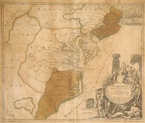
| Map of Virginia and Maryland This map probably dates to the earliest colonization of the eastern seaboard. It includes extensive detail throughout the Chesapeake Bay area gathered by John Smith and other early explorers. It shows Virginia and Carolina as very small and Spanish-controlled Florida extending to the northwest of both colonies. The Atlantic Ocean along the coast is labeled the “Sea of Virginy”. Maps were used by the Custis and Lee children, and perhaps the enslaved people, to study early geography of the region.
Paper, mahogany, gilt. L 73.8, W 63.8 cm |
| Back |