
NPS Photo There are 28 major glaciers on Mount Rainier and numerous unnamed snow or ice patches, which cover about 30 square miles (78 km2). Mount Rainier's glaciers are important indicators of climatic change and essential sources of water, supporting five major river systems. The Emmons Glacier has the largest area (4.3 square miles) and the Carbon Glacier has the lowest terminus altitude (3,600 feet) of all glaciers in the contiguous 48 states.
Glacier Features
Learn about the unique features and formations created by glaciers and glacial forces. 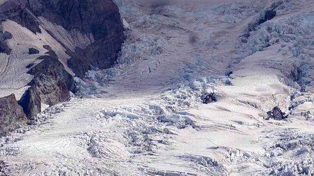
Mount Rainier Glaciers
Map and descriptions of some of Mount Rainier's major glaciers. Glacier Research & Resources

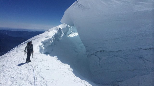
NPS Photo Debris Flows from GlaciersHistorically, glacial outburst floods, torrential rains, and stream capture have caused small to moderate size debris flows. Most occur in drainage systems with large glaciers. A glacial outburst flood originating from the South Tahoma Glacier created a debris flow along Tahoma Creek on August 13, 2015 (news release). Less common are debris flows triggered by a drainage diversion in an un-glaciated drainage basin. For example, Kautz Glacier meltwater diverting into the Van Trump Basin triggered debris flows on the south side of the mountain in 2001 and 2003. Glacial outburst floods are one type of geohazard in the park. Status of the Glaciers
NPS Photo Status of the Glaciers - Summer 2018 Update(posted 11/9/2018)
The Inventory and Monitoring glacier mass balance monitoring program wrapped up the field season in October with fall checks to monitoring sites on the Emmons & Nisqually glaciers. Preliminary results suggest winter accumulation in 2018 was slightly above the 2003-2017 average for the Emmons & Nisqually. The largest snow depths measured this spring exceeded 10 meters on Nisqually Glacier and 7 meters on Emmons. Summer melt was also above average. The most melt occurred at the lowest elevations of glaciers, exceeding 12 meters! With the field season complete, data analysis can begin. From these point data, glacier wide estimates of winter, summer and annual (net) balances can be made, as well as important streamflow contributions to these watersheds from glaciers. 
NPS Photo Status of the Glaciers - Summer 2015 Update(posted 8/7/2015) A quick review of historic data reveals, not surprisingly, that the melt in the first part of the summer of 2015 is greater than early season melt from any previous year dating back to 2003, when monitoring began. For the first time since monitoring began, field crews might have to re-drill ablation stakes in the bare ice of the lower Nisqually because stakes might melt out before the season is over. The debris noted in the photo actually insulated the glacier from melt, so we see much lower rates of melt on the debris covered areas of the glacier than we do on bare ice. At 6,100 feet (1,859 m) on the non-debris covered lower Nisqually we have 10.8 feet (3.3 m) of snow melt plus an additional 6.5 feet (2 m) of ice as of 7/28/2015. Our final check will be the first to second week of October - still two more months of potential melt! Learn more about glacier monitoring at Mount Rainier and other parks.
Descriptive TranscriptTimelapse using images from a webcam that looks up towards the summit of Mount Rainier. The summit is covered by snow and glaciers. The glaciers split in two around a rocky promintory in the foreground of the image. As the timelapse proceeds, the glacier ice appears to flow down the mountain, with crevasses forming and growing in the ice as the season progresses. Climbers set up tents and travel on the rocky outcrop and glaciers.
Visit our keyboard shortcuts docs for details
This 65-frame time lapse video comprises the 7:00 am view of the Emmons and Winthrop Glaciers from Wednesday, June 28, 2017 - Monday, September 11, 2017 from the Camp Schurman webcam. (Note that there are several frames during this time that are missing). The time lapse reveals many interesting features of the glacier, including opening and closing crevasses, zones of different speeds on each glacier, melting of the latest year's winter snow accumulation, rock falls, avalanches, and many more. It is through time lapse videos like this that we can truly see the dynamic nature of glaciers as rivers of ice. (no audio) Looking into the future...Climate Change Science | ||
Last updated: March 19, 2025