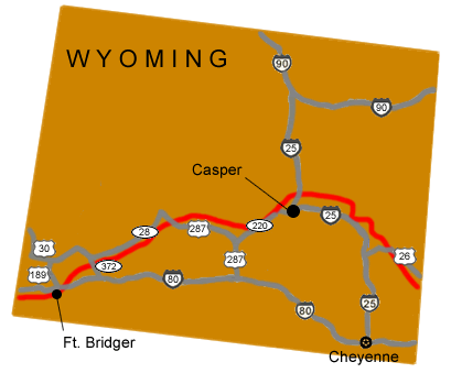
National Park Service LogoU.S. Department of the InteriorNational Park ServiceNational Park Service
National Park Service:  U.S. Department of the InteriorNational Park Service Arrowhead
Mormon Pioneer National Historic TrailThe Mormon Pioneers passed through Echo Canyon not long after leaving Ft. Bridger, Wyoming on their way to the Salt Lake Valley.
view map
text size:largestlargernormal
printer friendly
Mormon Pioneer National Historic Trail
Auto Tour Route - Wyoming

To follow the Auto Tour Route of the Mormon Pioneer National Historic Trail west through Wyoming, from Nebraska to Utah: follow the driving directions listed below.


Map image of the auto tour route driving directions for the Mormon Pioneer NHT across Wyoming.
NPS Image
Map image of the auto tour route driving directions for the Mormon Pioneer NHT across Wyoming.
 

From the Nebraska - Wyoming border:

1. Take U.S. Route 26 west to Interstate 25.
2. Turn north onto Interstate 25.
3. Take Interstate 25 west to State Route 220 at Casper.
4. Turn west onto State Route 220.
5. Take State Route 220 to U.S. Route 287.
6. Turn west onto U.S. Route 287.
7. Take U.S. Route 287 west to State Route 28.
8. Turn West onto State Route 28.
9. Take State Route 28 west to State Route 372.
10. Turn south onto State Route 372.
11. Take State Route 372 to Interstate 80.
12. Turn west onto Interstate 80.


Total original route miles in Wyoming: 511

Back to the auto tour route map.

Elkhorn River Crossing near Fremont, Nebraska.  

Did You Know?
The Elkhorn River, a few days from the Mormon Winter Quarters at Council Bluffs, was one of the first major water crossings encountered by the Mormons. In April 1847, several days were spent building rafts to ferry the first 72 wagons across the flooded river.
more...

Last Updated: October 31, 2006 at 13:37 EST