An official website of the United States government
Here's how you know
Official websites use .gov A
.gov website belongs to an official government
organization in the United States.
Secure .gov websites use HTTPS A
lock (
) or https:// means you've safely connected to
the .gov website. Share sensitive information only on official,
secure websites.
Junction of the Petroglyph and Spruce Canyon Trails
NPS/Spencer Burke
For thousands of years, people have traveled across this landscape of sloping mesas (cuestas), expansive vistas, and rugged canyons. Today, you can follow in their footsteps by exploring 30 miles of park trails.
Trail Regulations
It is illegal to hike off trail in Mesa Verde. Hiking is allowed only on designated trails.
Pets are not allowed on trails, except for Nordenskiöld Site #16, Badger House Community, and Long House Loop.
Please do not smoke on trails. Mesa Verde is subject to devastating wildfires.
The park elevation is over 7000 ft (2134 m) where it is windy and dry.
Prevent dehydration by drinking plenty of fluids.
Prevent altitude sickness, by acclimating to the area before engaging in any activity.
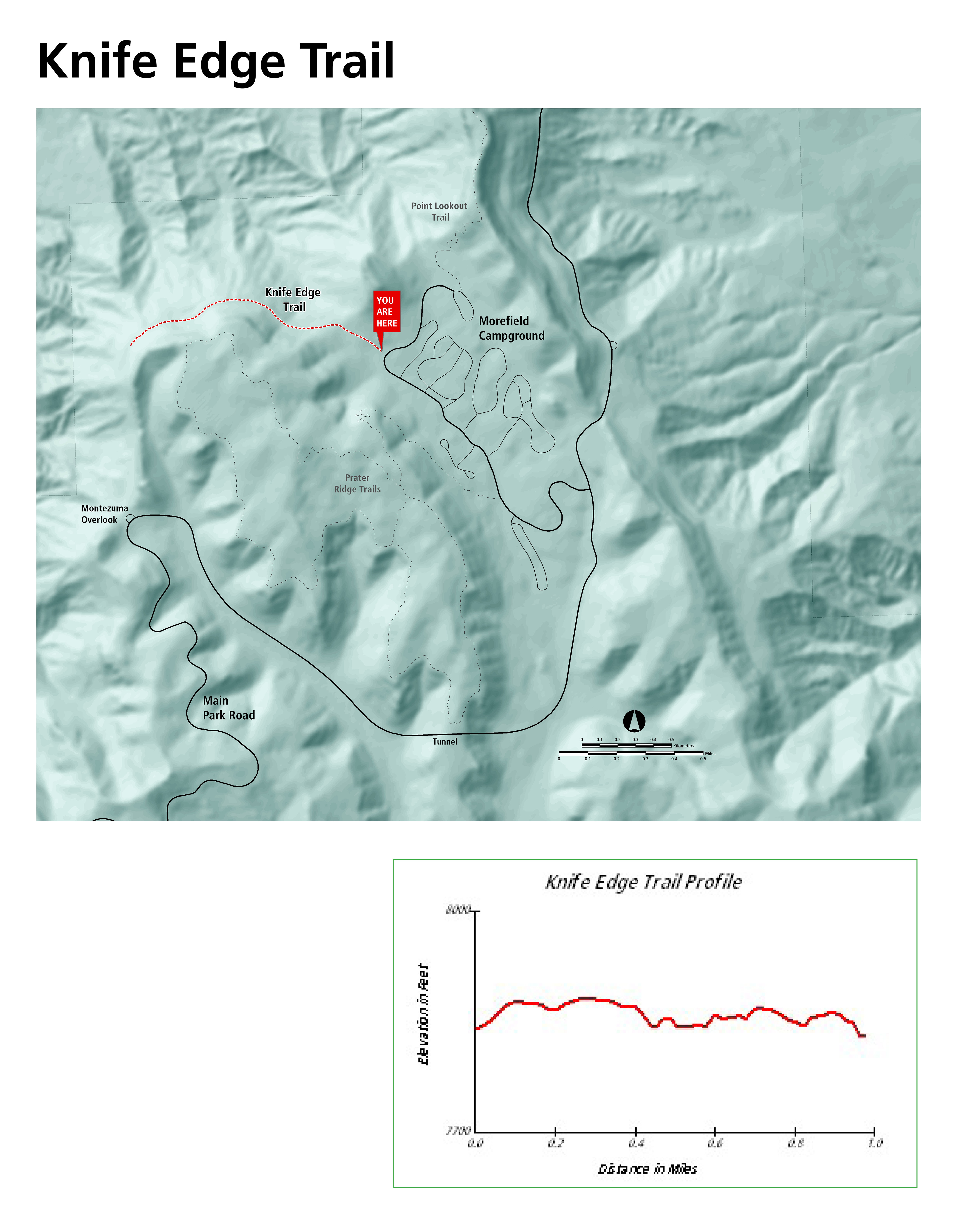
Morefield Canyon
Knife Edge Trail
Knife Edge Trail Difficulty: Easy
Distance: 2 miles (3.2 km) roundtrip
Elevation Change: 60 feet (18 m)
Trailhead: Morefield Campground
The trail follows a section of the historic park road, built in 1914 along Mesa Verde’s north escarpment. Views to the northwest make this trail a great place to enjoy sunset and the ecosytems are birding hotspot. A serious rockfall occurred along the last quarter of Knife Edge Trail. Please do not enter the rockfall area.
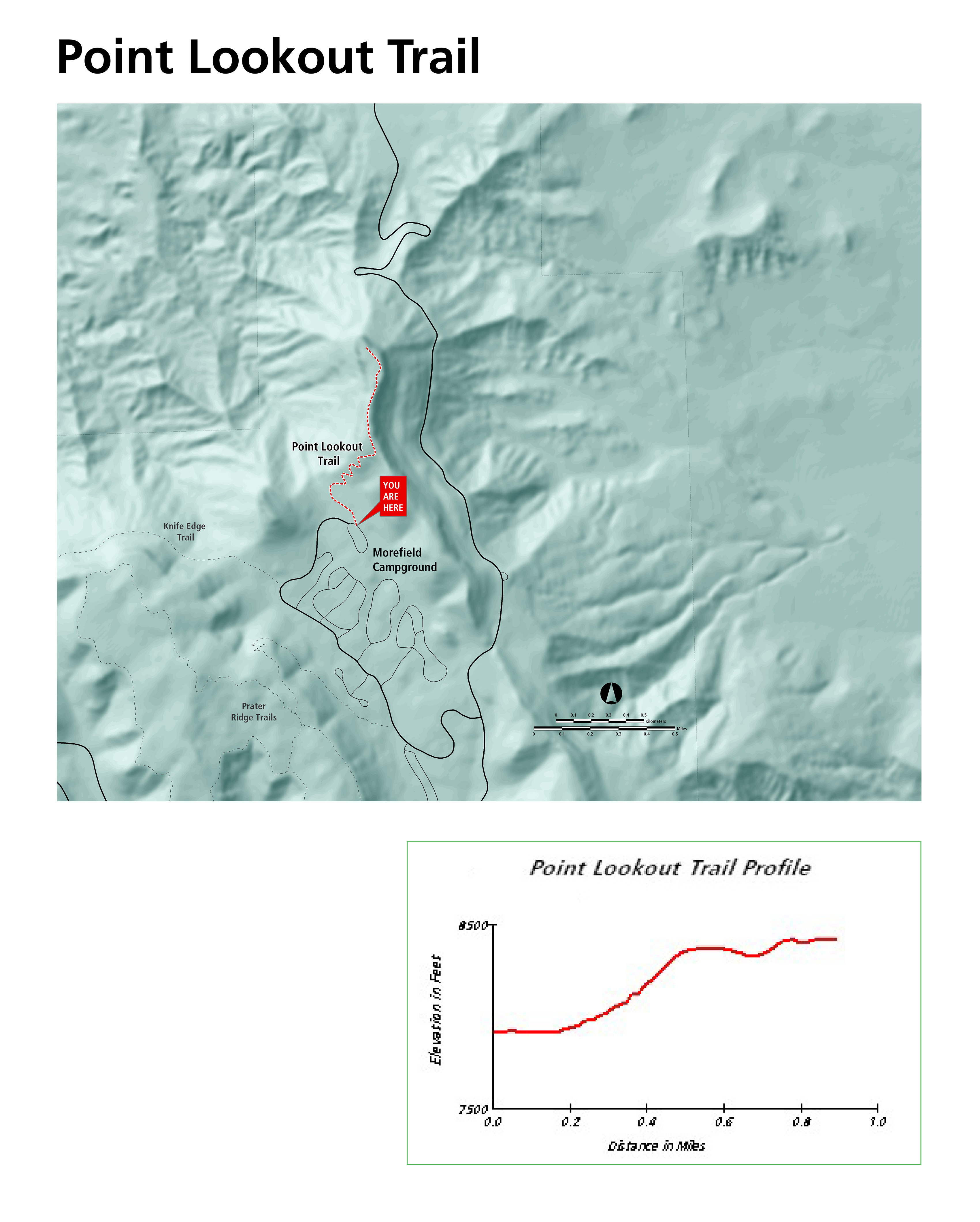
Point Lookout Trail Difficulty: Moderate
Distance: 2.2 miles (3.5 km) roundtrip
Elevation Change: 400 feet (122 m)
Trailhead: Morefield Campground
Steep switchbacks climb from Morefield Canyon to the top of Point Lookout, the iconic geological formation towering above the park entrance. Hikers are rewarded with views of the San Juan and La Plata Mountains and the Mancos and Montezuma Valleys.
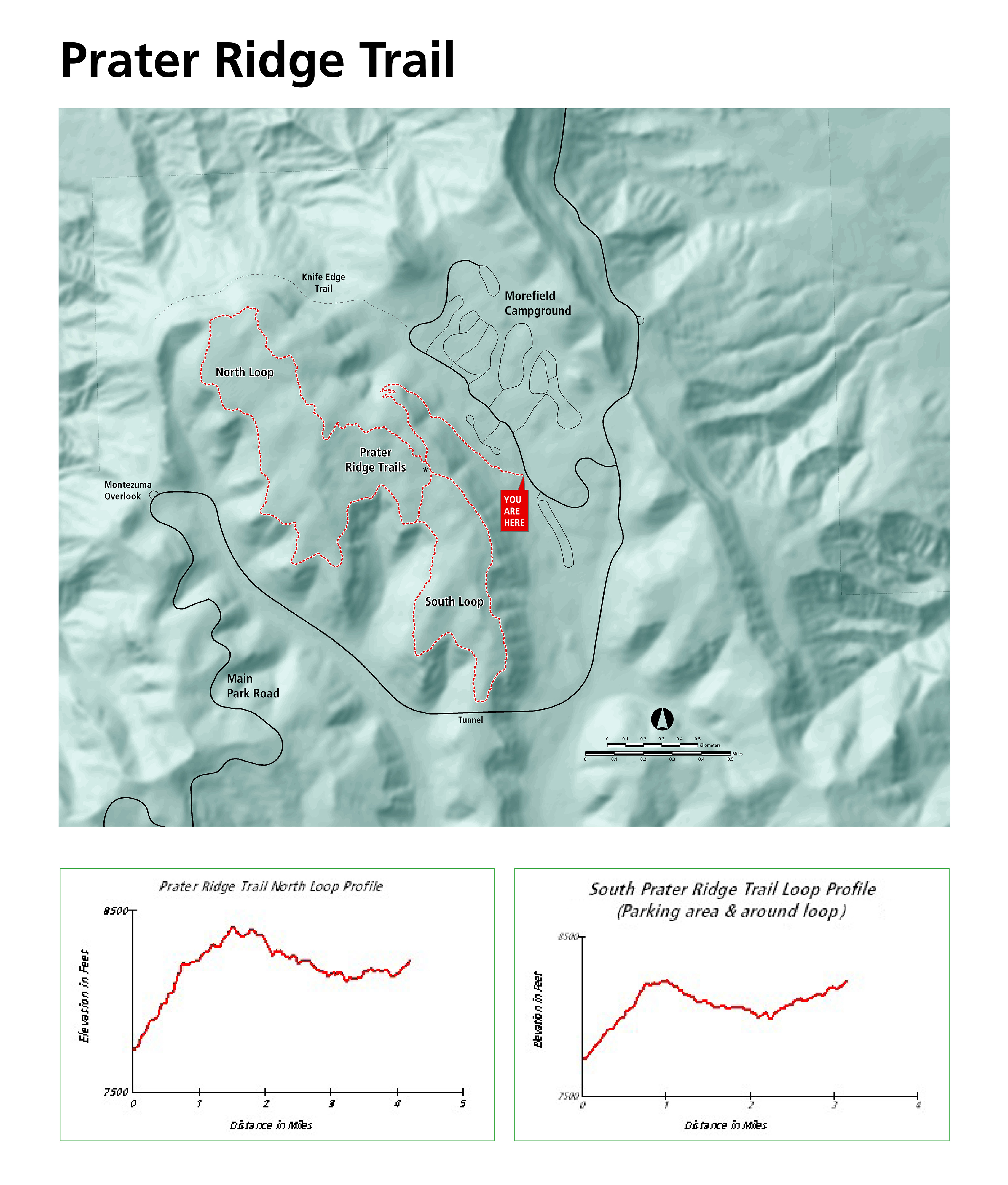
Prater Ridge Trail Difficulty: Strenuous
Distance: 7.8 miles (12.6 km) roundtrip
North Loop: 5.7 miles (9.2 km) roundtrip; South Loop: 4.6 miles (7.4 km) roundtrip
Elevation Change: 675 feet (205 m)
Trailhead: Morefield Campground
After climbing 1.1 miles (1.8 km) to the top of Prater Ridge, hikers may choose to hike either or both loops. Turn right for the longer north loop (3.6 miles/5.7 km), to follow the mesa’s edge high above Montezuma Valley, or left for the south loop (2.4 miles/3.9 km), which looks over Prater and Morefield Canyons.
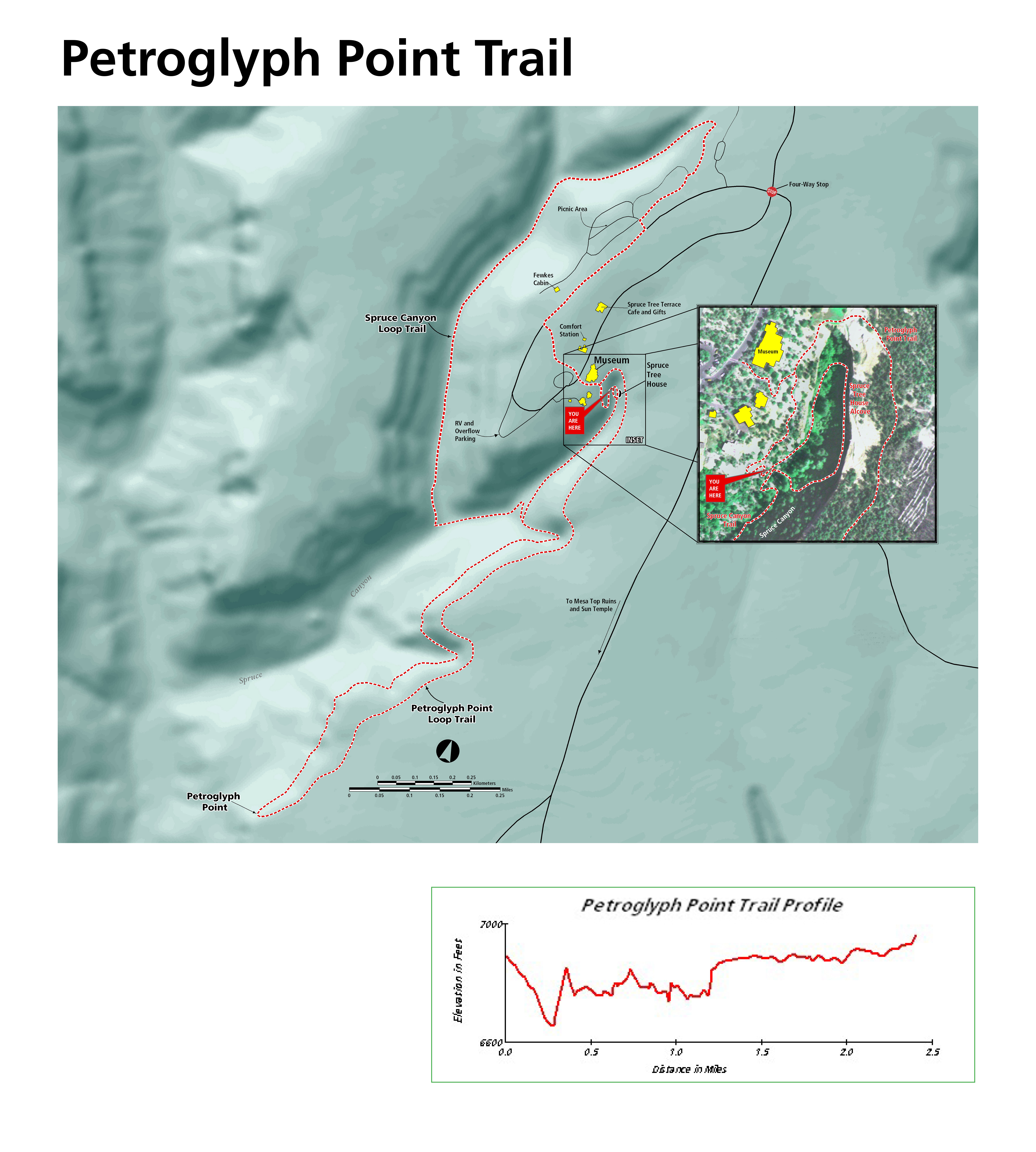
Petroglyph Point Trail It is highly recommended the trail be hiked counterclockwise.
Difficulty: Very Challenging—unmaintained with a narrow passage, stone stairs, steep edges, loose rock, scrambling required.
Distance: 2.4 miles (3.9 km) roundtrip
Elevation Change: 227 feet (69 m)
Trailhead: Spruce Tree House Overlook, by the Mesa Verde Museum
A rugged and adventurous trail with steep drop offs. Hikers traverse the side of Spruce Canyon, squeezing between boulders and descending narrow stone staircases to reach a large petroglyph panel at 1.4 miles (2.3 km). From here, hikers must climb a 100-foot (30 m) cliff, scrambling up rocks and uneven sandstone steps to the mesa top, before returning through pinyon-juniper forest on the mesa top to complete the loop.
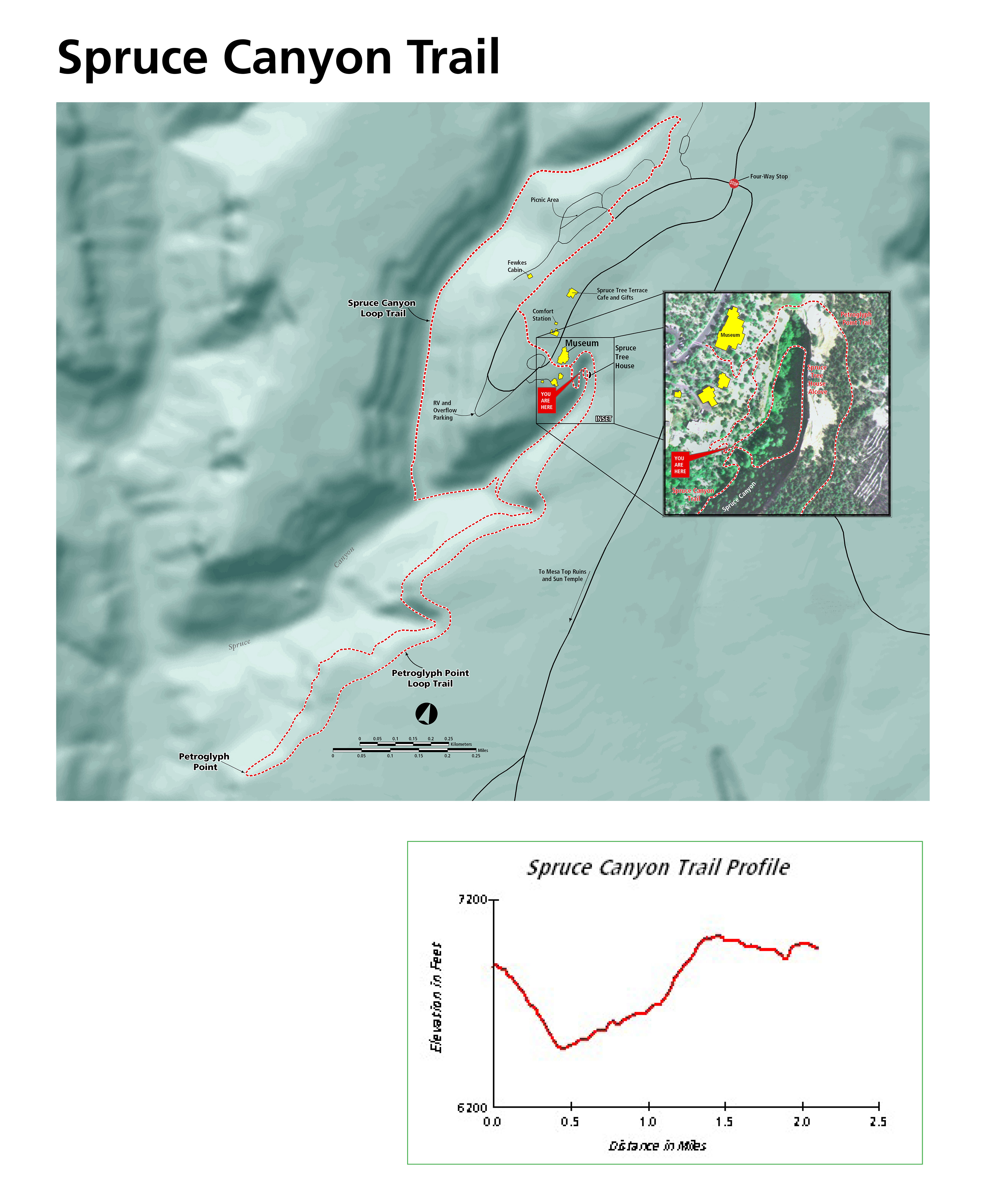
Spruce Canyon Trail
Difficulty: Strenuous
Distance: 2.4 miles (3.9 km) roundtrip
Elevation Change: 558 feet (170 m)
Trailhead: Spruce Tree House Overlook, by the Chapin Mesa Museum
This scenic trail leads hikers down swithchbacks and through shady Spruce Canyon, showcasing Mesa Verde’s diverse ecosystems. A steep climb leads out of the canyon and then passes through the picnic area to return to the museum.
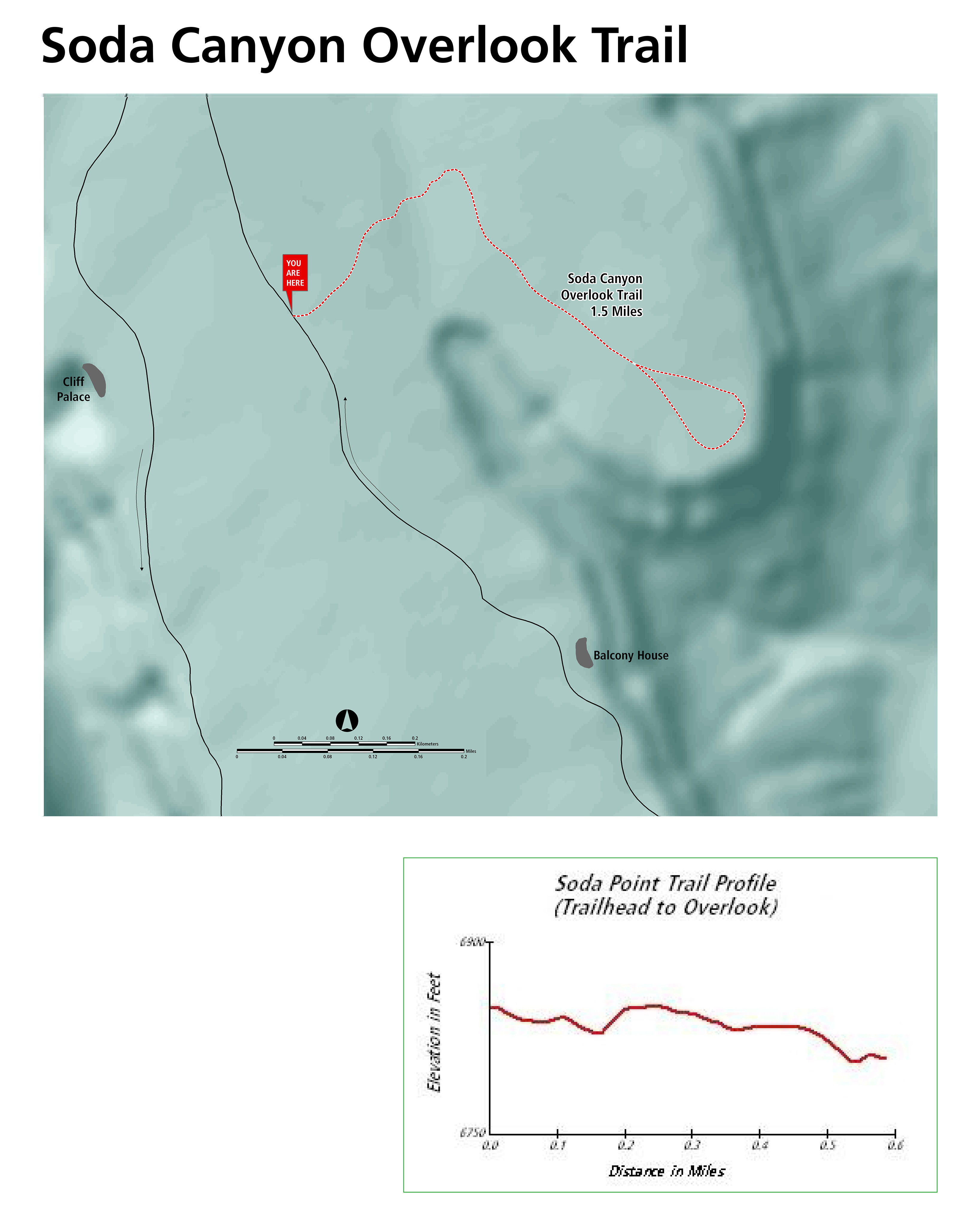
Soda Canyon Overlook Trail Difficulty: Easy
Distance: 1.2 miles (1.9 km) roundtrip
Elevation Change: 70 feet (21 m)
Trailhead: on the Cliff Palace Loop, 0.5 miles (0.8 km) past Balcony House
A level out-and-back trail that winds through pinyon-juniper forest to three overlooks, where hikers are rewarded with views of Balcony House and other cliff dwellings across Soda Canyon.
Farming Terrace Trail Difficulty: Easy
Distance: 0.5 miles (0.8 km) roundtrip
Elevation Change: 150 feet (45 m)
Trailhead: on the Cedar Tree Tower road
This short trail drops into a side drainage of Soda Canyon past a series of well-preserved check dams built by Ancestral Pueblo farmers.
Far View Sites Difficulty: Easy
Distance: 0.75 miles (1.2 km) roundtrip
Trailhead: Far View Sites parking area, along main park road, four miles north of museum. Parking is limited to vehicles under 25 feet.
This mesa-top community includes Far View House, four other villages, and a dry reservoir. In ancient times, the community was a place of modest homes interspersed with small farm fields. It was a place filled with people, vibrant life, and constant change. As you follow the woodland trail among the six sites, read the trailside signs to learn about Ancestral Pueblo life in the surrounding landscape between 900 to 1300 CE.
Chapin Mesa
Wetherill Mesa
Wetherill Mesa is open May 23 to September 29, 2025. Visiting the mesa can take a full day. Sites are only seen by hiking or biking.
Entry gate opens at 8:30 am and the last entry of the day is 2:00 pm
All visitors must exit by 4 pm when the gate closes for the night.
Closed on Tuesdays and Wednesdays
All Wetherill Mesa trails pass through areas burned in the 2000 Pony Fire. There is no shade.
Bicycles are not permitted on the 12-mile road the pavillion. From the parking lot, bicycles, including e-bikes are permitted to overlooks and trailheads.
Pets are permitted on all trails except for the trails leading into Step House and Long House.
Step House Difficulty: Moderate
Distance: 1 mile (1.6 km) roundtrip
Elevation Change: 165 ft (50 m)
Trailhead: Wetherill Mesa Kiosk
The Step House trail is open only when staffed by a ranger. This paved-and-gravel trail loops into Long Canyon and through Step House, a unique cliff dwelling featuring two distinct periods of Pueblo architecture.
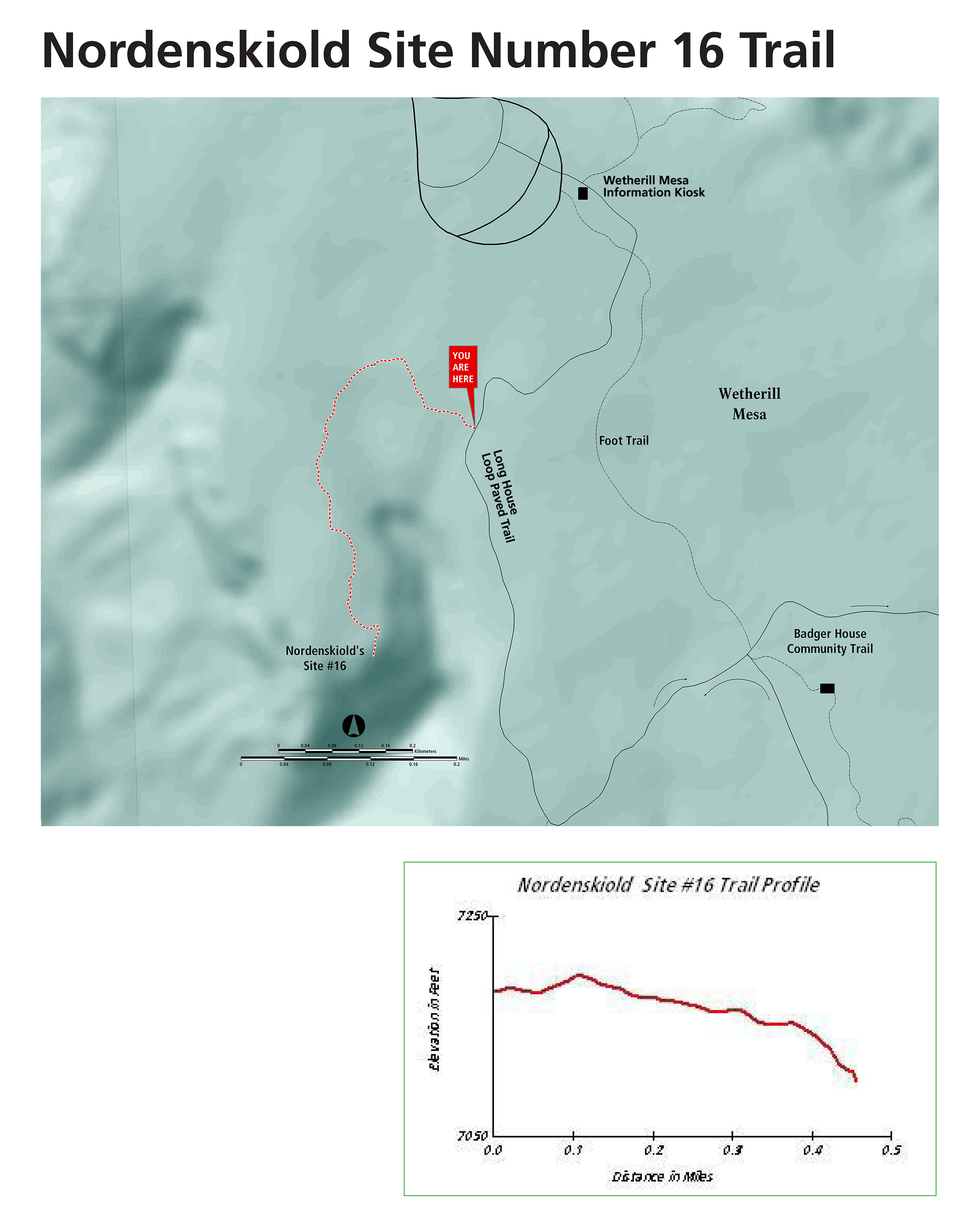
View of Nordenskiold Site No. 16 from trail
Nordenskiold Site No. 16 Trail Difficulty: Moderate
Distance: 2 miles (3.2 km) roundtrip
Elevation Change: 95 feet (29 m)
Trailhead: Wetherill Mesa Kiosk
Pets allowed
Follow the gravel trail south from the Wetherill Mesa kiosk, then turn right at the sign to follow the Nordenskiöld Site #16 Trail to an overlook of a cliff dwelling in Rock Canyon. This village of about 50 rooms is named for the Swedish scholar Gustaf Nordenskiöld, who excavated the site in 1891.
Badger House Community Trail Difficulty: Moderate
Distance: 2.25 miles (3.6 km) roundtrip
Elevation Change: 111 feet (34 m)
Trailhead: Wetherill Mesa Kiosk
Pets allowed
Take the gravel trail south from the Wetherill Mesa Kiosk, pass the junction to Nordenskiöld Site #16 Trail and cross the paved Long House Loop to explore the 1-mile (1.6 km) loop through the Badger House Community—four excavated mesa top villages representing 600 years of Pueblo history.
Long House from Overlook off the Long House Loop Long House Loop Difficulty: Moderate
Distance: 5 miles (8 km) roundtrip
Elevation Change: 177 feet (54 m)
Trailhead: Wetherill Mesa Kiosk
Pets allowed
This paved trail loops around the top of Wetherill Mesa to the Badger House Community (2.5 miles/4 km roundtrip), Long House Overlook (3 miles/4.8 km roundtrip) and Kodak House Overlook (4.5 miles/7.2 km roundtrip). This trail is open to hiking, biking, and pets.


