National Park Service LogoU.S. Department of the InteriorNational Park ServiceNational Park Service
National Park Service:  U.S. Department of the InteriorNational Park Service Arrowhead
Mesa Verde National ParkSketch map of site.
view map
text size:largestlargernormal
printer friendly
Mesa Verde National Park
Site Survey Data
Two site maps, one with pottery shards and lithic in foreground.
NPS Photo
Site maps, completed in 2006


Baseline site survey data is collected at all sites and serves as the backbone of documentation necessary for every archeological site at Mesa Verde National Park. Over 4,700 sites in the park have received this level of documentation since the first survey projects were conducted in the 1930s. Currently, sketch maps, photographs, and a GPS location are part of this documentation package. Our goal is to update the site survey information on all sites documented prior to 1996 when our current methodology was established.


Archeologist documenting a collapsed pueblo.

NPS Photo

Documenting a rubble mound that represents a pueblo, 2001


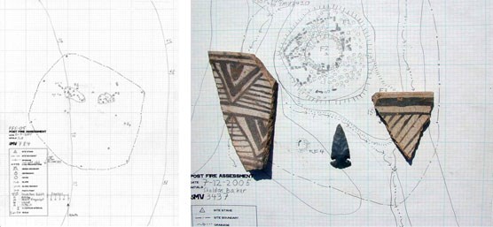
Artifacts are photographed and identified in the field. Artifacts can help determine the function of a site during the time period it was occupied.


Kiva courtyard at Spruce Tree House  

Did You Know?
A subterranean kiva remained 50 degrees Fahrenheit all year round. So for the Ancestral Puebloans, it stayed cool in the summer, and only a small fire was needed to keep it warm in the winter.

Last Updated: November 04, 2008 at 17:32 EST