
NPS Photo OverviewMore than 200 million years ago, all of the continents had collided and formed the supercontinent Pangea, thrusting up huge mountains in what is now North America. At the dawn of the Jurassic period, Africa and North America tore away from each other, causing eastern North America's continental crust to thin and crack. These cracks caused the land to sink down and form basins. Over time, as the Blue Ridge Mountains eroded, rain and streams carried the eroded sediment to lower elevations. Once the sediment and flowing water, reached the bowl-shaped basins, they created lakes underlain by silt and clay. The early Triassic rift basin was thus filled with Triassic and Jurassic sediment, as well as Triassic and Jurassic fossils. Over time the loose silt and clay of the lake beds hardened into siltstones and shales containing evidence of a long-lost habitat. Among fossils, the siltstones preserve ripple marks, mudcracks, root asts, and more. 
NPS photo The thinned continental crust and cracks also provided easy access for rising magma to reach the surface, leading to the formation of diabase dikes like the one which underlies the western side of the park. As the hot magma rose through the crust, it pushed through siltstone, resulting in contact metamorphism. Evidence of this thermal metamorphism can be found in bands of shale, hornfels and altered siltstone which surround the dike. You can examine each segment of Manassas National Battlefield's geologic history starting with red siltstones and grey shales in the east, and ending with diabase and metasedimentary rocks in the west. 
You can examine each segment of Manassas National Battlefield's geologic history starting with red siltstones and grey shales of the Bull Run formation in the east, and ending with diabase and metasedimentary rocks in the west. Geologic formations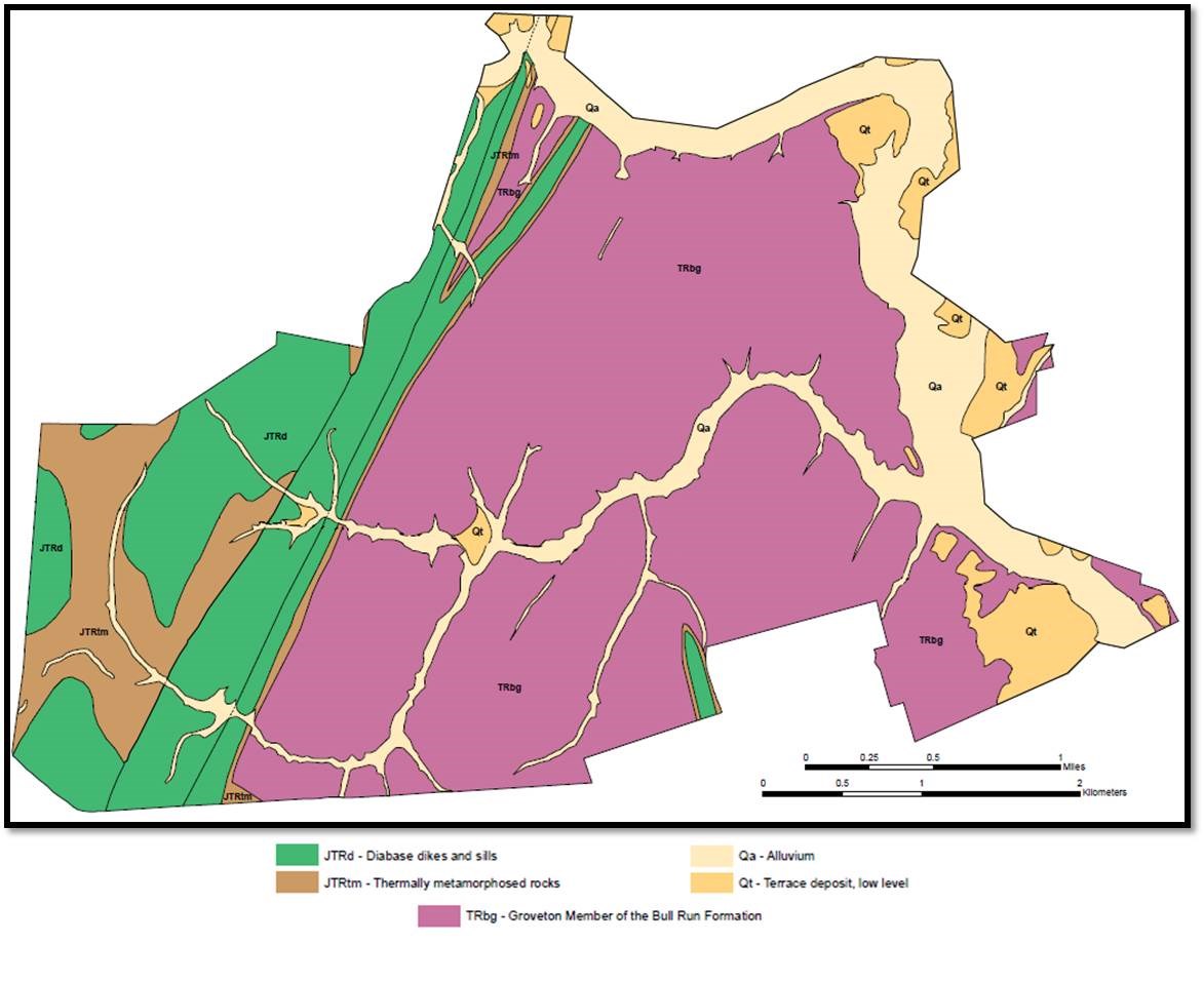
NPS 
NPS Bull Run FormationThe best locations to view large exposures are along the Bull Run River, road cuts, and the various branches which carve the park's landscape such as Young's Branch, Holkum's Branch, and Dogan's Branch. Thermally Metamorphosed RocksWhen the siltstones and sandstones of the Bull Run Formation were exposed to the high temperatures of the diabase dike, the mineralogy of the rocks became unstable and began to change. The small muscovite grains in the micaceous rich sandstones grow; clay transforms into biotite, cordierite, quartz, and plagioclase resulting in hornfels; and the calcite rich lenses transform into marble. Most of the hornfels and altered sandstones/siltones have eroded away or been buried, making them difficult to find within the park. 
NPS Diabase DikeThe western half of the park contains substantial areas underlain by diabase, a mafic igneous rock. This bedrock is well expressed in a narrow dike that extends northward through the park, running under Stuart's Hill, Brawner Farm, and laying to the east of Groveton. As Pangea was splitting apart, magma from the mantle began to upwell and push through weak and cracked continental crust creating sills and dikes. With the rift basin forming right here in the park, an intruding diabase dike pushed the overlaying Bull Run formation up and thermally altered some of the surrounding siltstone. Over time the overlaying siltstones and sandstones have eroded away, exposing the diabase. As the diabase weathers, the rock produces a thick, calcium-rich soil cover which obscures a majority of the unit. Despite the thick soil cover, spheroidal boulders, rounded by wind and rain, are still visible throughout the western side of the park. The diabase itself is a dense, medium-grained, dark-gray to black rock composed primarily of feldspar and pyroxene minerals (Lee, 1979). The medium grained, porphyritic, texture formed as the magma cooled slowly within the earth, allowing each crystal time to grow. The mineralogy of these crystals are the product of the chemical composition of the magma. The mafic nature of the diabase suggests the magma was rich in Iron and magnesium. Deep Cut, a key location in understanding the park's history, is rich with diabase. Boulders litter the surrounding trails and the entire cut is flooded with exposed and worked diabase. ReferencesLee, K.Y. 1979. Triassic-Jurassic geology of the northern part of the Culpeper basin, Virginia and Maryland. U.S. Geological Survey Open-File Report 79-1557, 29 pp., 16 pl., scale: 1:24,000. Further reading |
Last updated: November 1, 2022