|
Washington Department of Natural Resources
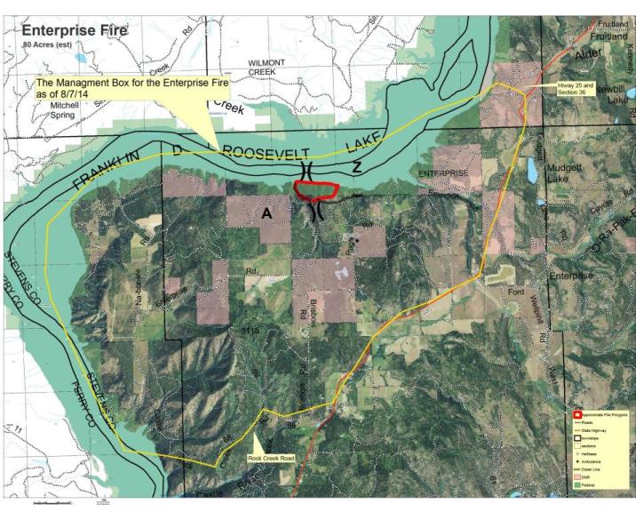
Contact: Denise Bausch, 509-754-7886 The Enterprise Fire, burning along the shore of Lake Roosevelt near Fruitland, WA, has not grown beyond 80 acres since yesterday, according to the Washington Department of Natural Resources. This lightning-caused wildfire is still active but the low winds today gave fire crews a chance to work on strengthening the defensible line they have created around the fire. The Washington Department of Natural Resources hopes to secure the fire line by tomorrow and begin back burns on Sunday provided the weather continues to cooperate. The back burns will increase the amount of smoke in the area which is already heavy at times due to the Devil's Elbow Complex Fire located along Highway 21 north of Keller. Even though the fire has not grown, the area remains under a level 2 evacuation. The hyper-reach alert system will continue to send out notices to people in the area through their landlines and/or cell phones. If you have not signed up to receive Hyper-Reach notices through your landline phone or your cell phone, visit the Stevens County Website at https://secure.hyper-reach.com/comsignupw.jsp?id=41001 to sign up. There are currently 100 fire crew working on this fire with an additional 60 crews expected to arrive by tomorrow. They are assisted by two helicopters to help slow the spread of the fire. Fire crews continue to make progress but are slowed by the steep terrain and primitive road conditions in this area of Lake The partial Lake Roosevelt closure and camping restrictions announced Wednesday remains in place between river mile 52 and Please take a moment for your safety as well as the fire fighters. Pay attention to the weather reports and stay out of the area if you don't live there. By staying out of the area, it is easier for the fire fighters and emergency personnel to get where they need to go quickly. Unauthorized visitors to the area hinder the fire fighters ability to effectively fight this fire and prevent its spread. For the latest information, check the Lake Roosevelt National Recreation Area website at www.nps.gov/laro. Information can also
|
Last updated: February 28, 2015