Illustration: Anthony Ross ANCIENT SEAS AROUND LAKE MEAD Lake Mead National Recreation Area is located in a historically geologically active region of the planet. Over time the region has been subjected to earthquakes, volcanoes and from time to time overrun by shallow inland seas.
In the Precambrian era (4 billion years ago to 570 million years ago) our planet looked quite different. The region just to the west of Lake Mead was the edge of the continent of what will become North America. The Las Vegas area was beach front property, but not for long...geologically.
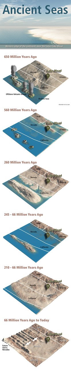
650 MILLION YEARS AGO The seas next to the edge of the continent were shallow and warm. The region of North America was located south of the equator. But at this time, there was only rock in varying forms, plants and animals have yet to exist. The coast would have looked like modern day Saudi Arabia where it meets the seas.
By 650 million years ago most of North America had been planed off through erosion to a nearly flat surface with some areas of gently rolling hills.
560 MILLION YEARS AGO By now the sea began to slowly invade North America. The area of Lake Mead was submerged by 520 million years ago. This would not be the first time, until the land that eventually becomes California and western Nevada forms, the seas will have invaded and retreated more than 50 times, creating what would eventually be the sedimentary rocks and strata we see today.
As the shoreline moved eastward the water in the Lake Mead region became deeper and deeper allowing finer and finer sediments to deposits. This Tapeats beach sand was eventually covered with fine silt and clay that later hardened to siltstone and shale. Off shore shoals and reefs became home for the teeming plant and animal life that were established in the Lake Mead region. During these sea level changes countless calcium carbonate skeletons accumulated layer upon layer on the sea bottom. The gradual sinking of the sea bottom kept pace with skeletal accumulation, so the sea remained shallow while the sediment pile below got thicker and thicker. Burial converted the calcium carbonate skeletons to layered limestone and dolomite rock which is up to 2,000 meters (more than 6,000 feet thick) at Lake Mead.
260 MILLION YEARS AGO Plate techtonics at this time affected all land masses. Evidence for this plate tectonic upheaval is recorded in the rocks formed during the Permian Period at what was to be Lake Mead National Recreation Area. Mountains that formed when South America and Africa collided with North America lifted the land so that the shallow seas that had covered the west for much of the previous 300 million years receded. Sediment eroded from the newly uplifted ancestral Rocky Mountains was deposited in this area by a large system of rivers. As the climate became increasingly arid, some of the sediment was transported from the river beds by wind and deposited as large dune fields. Minute quantities of iron in these stream and dune deposits gradually oxidized, turning them a distinctive brick-red color - geologists call these 'red beds'.
260 TO 66 MILLION YEARS AGO The last of the warm shallow marine seas invaded the Lake Mead area early during the Triassic Period. Later the sea receded to the west and marine conditions gave way to continental forest, river, mud flat, flood plain, lake and dune environments. Gravel, sand and silt deposited in these environments eventually hardened to form conglomerate, sandstone and siltstone. Volcanic ash preserved in these sedimentary rocks provides evidence of explosive volcanic eruptions associated with plate collision continuing to the west. The region must have been covered by great forests during the time these sediments were deposited because certain layers contain petrified wood nearly everywhere they are found.
66 MILLION YEARS AGO TO TODAY About 18 million years ago a tectonic upheaval began that profoundly marked the present Lake Mead landscape.
Sometime about 18.5 million years ago an episode of major crustal extension stretching and volcanic activity initiated in the Lake Mead region. Hot magma, rising from deep in the crust built imposing stratovolcanoes. Tremendous explosive volcanic eruptions blanketed the region with ash, volcanic debris and lava flows. Deep beneath the volcanoes molten cauldrons of rock called magma chambers supplied the volcanoes above. As new magma chambers and volcanoes formed, older magma chambers cooled to form solid igneous rock masses called plutons. Fortification Hill, Hamlin/Cleopatra and other volcanisms at Lake Mead formed during this period and their remnants are visible today.
Lake Mead is part of the Basin and Range Province and it was during this time that large scale plate tectonics caused this area to stretch more than 300 miles, adding to the real estate of Nevada and California while causing the north/south mountain formations you see today.
Special thanks to the United States Geological Survey for the information in this article.
|
Last updated: September 2, 2020