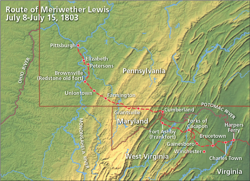
The route which Meriwether Lewis traveled from Harpers Ferry, Virginia to Pittsburgh, Pennsylvania, between July 8 and July 15, 1803, has not been well documented.1 The only primary source we have is a letter Lewis penned to President Jefferson from Harpers Ferry on July 8, 1803:
I shall set out myself in the course of an hour, taking the route of Charlestown, Frankfort, Uniontown and Redstone old fort to Pittsburgh, at which place I shall most probably arrive on the 15th.2
Based on this travel itinerary, on the confidence Lewis expressed in his anticipated arrival date, and on extensive documentation of the primary travel routes across this region in the late 18th and early 19th centuries, we can deduce with some certainty the route Lewis took across the Appalachian Mountains to the Ohio River.
Map showing travel route of Meriwether Lewis from Harpers Ferry to Pittsburgh from July 8 to July 15, 1803
Graphic by David T. Gilbert
General Edward Braddock Among the earliest records we have for travel over this general route come from the march of Gen. Edward Braddock’s British expeditionary force, which was sent to clear the French out of the Ohio country in the spring of 1755.3 On May 2, 1755, Sir Peter Halkett’s 44th Regiment crossed the Blue Ridge at Vestal’s [Keys] Gap, about six miles south of present-day Harpers Ferry. Halkett’s troops marched through Charlestown [Charles Town, W.Va.], proceeded southwest through Smithfield [Middleway, W.Va.], then turned south to Abril’s Ford on Opequon Creek. On May 4, Halkett’s troops forded Opequon Creek and rested at Littler’s Tavern [Brucetown, Va.].
At Littler’s Tavern, Halkett’s 44th Regiment was joined by Col. Thomas Dunbar’s 48th Regiment, which had forded the Potomac River at Williams Ferry [Williamsport, Md.] and proceeded south along the “Waggon Road” [Valley Turnpike or U.S. Route 11]. Gen. Edward Braddock, accompanied by 23-year-old George Washington, forded the Potomac River at Swearingen’s Ferry [Shepherdstown, W.Va.] and joined the 44th and 48th Regiments at this same place.
From Littler’s Tavern, the 44th and 48th Regiments marched west through Cedar Grove, across Babbs Run, and over Hunting Ridge to present-day Gainesboro, Va., hauling with them 29 pieces of artillery, 407 wagons, 400 pack horses, and a herd of livestock. This route, which appears on an 1863 map prepared by the U.S. Army, passed about six miles north of Winchester, Va.4
Braddock’s force continued west through Cross Junction, camped near present-day Whiteacre, crossed Big Timber Ridge, and bivouacked on land owned by Henry Enoch and surveyed in 1750 by George Washington [Forks of Cacapon, W.Va.]. In what was described as the most difficult stretch of the entire march to the Ohio River, Braddock’s army crossed Spring Gap Mountain near present-day Slanesville, W.Va. Dunbar’s 48th Regiment reached Wills Creek [Cumberland, Md.] on May 10, 1755. Halkett’s 44th Regiment arrived there on May 16.
“Braddock’s Road” and its subsequent incarnations as the Cumberland Road or National Road [U.S. Route 40] has been well-documented between Cumberland, Md., and the Monongahela and Ohio rivers in western Pennsylvania. On May 30, 1755, Braddock dispatched 600 men under the command of Maj. Russel Chapman to clear a road 12 feet wide west from Fort Cumberland. This road closely followed the Nemacolin Indian trail, which had been blazed by the Ohio Company in 1753.5
Braddock’s Road passed through the present-day towns of Frostburg, Md., Grantsville, Md., Addison, Pa., Somerfield, Pa., and Farmington, Pa., before veering away from Nemacolin’s trail. The road continued north through Connellsville to McKeesport, Pa. on the Monongahela River, just south of Fort Duquesne [Pittsburgh, Pa.]. It was near here, in a place subsequently named Braddock’s Field, that Gen. Edward Braddock was defeated and mortally wounded by the French and their Indian allies on July 9, 1755.
French and Indian War The defeat of Gen. Braddock and retreat of the British expeditionary force from western Pennsylvania threw the western Virginia frontier into turmoil. On August 14, 1755, Virginia governor Robert Dinwiddie appointed George Washington Colonel of the Virginia Regiment and Commander in Chief of the Virginia forces. Washington made Winchester, Va. his headquarters, and the roads and trails west of Winchester became essential conduits for moving men, supplies, and couriers to and from the western Virginia frontier.
One of Washington’s first acts was to order a stockade and fort built on the east side of Patterson’s Creek about 14 miles south of Fort Cumberland [Cumberland, Md.]. Fort Ashby, as this outpost became known, served to protect the main line of supply between Winchester and Fort Cumberland.6 A smaller fort, called Fort Capon or Enoch’s, was erected along this same supply route at the forks of the Cacapon River [Forks of Cacapon, W.Va.]. Traffic along this wagon road reached a peak during the last half of 1758 as the British campaign to capture Fort Duquesne proceeded across western Pennsylvania and began to draw supplies from western Virginia.
When the hostilities of the French and Indian War came to a close in 1764, Fort Ashby was probably abandoned. In the late 1700s and early 1800s, however, the site remained a bustling transportation link on the wagon road from Winchester to the Ohio River, and on December 5, 1787, the town of Frankfort was founded on the site of Fort Ashby. A local historian later wrote:
Before the completion of the Baltimore and Ohio Railroad [in 1854] Frankfort was on the direct route from Winchester to Wheeling over which hundreds of tons of merchandise passed monthly. It was the long wagon trains passing over this route that furnished business for two hotels in Frankfort. Many times has the Public Square been crowded over night with canvas covered wagons loaded with valuable merchandise.7
Frankfort was subsequently renamed Alaska, and is now incorporated as Fort Ashby, W.Va.
Whiskey Insurrection The importance of the wagon road from Winchester, Va., west to the Monongahela River was again documented during the Whiskey Insurrection of 1794. On Saturday, October 4, 1794, the “infantry and light Corps” of the Virginia militia departed Winchester to support the militias of Maryland, Pennsylvania, and New Jersey in suppressing the Whiskey Insurrection in western Pennsylvania.8 Among the Virginia militiamen was Meriwether Lewis, who mustered in as a private in T. Walker’s volunteer corps. Lewis and his fellow Virginians assembled at Winchester, and on October 4, 1794, he wrote his mother from their camp.9
Dr. Robert Wellford and the Volunteer Troop of Fredericksburg Cavalry followed the infantry, departing Winchester on the morning of October 6. Wellford documented the march in his diary:
October 6: “Rinkers, 9 miles” [Gainesboro, Va.]10 October 7: “a little beyond Copsyes,” at the “Black horse of John Coxey”, “17 miles” [Forks of Cacapon, W.Va.]11; “Crocks, 5 miles further” [unknown, but possibly “Cross Roads” or Slanesville, W.Va.] October 8: “Springfield, 17 miles from Crock’s” [Springfield, W.Va.] October 9: “Frankfort, 7 miles, where we had a most comfortable breakfast at McMeekins Tavern” [Fort Ashby, W.Va.]; “Fort Cumberland, 14 miles, making a journey of Sixty nine miles from Winchester.” [Cumberland, Md.]12
The main body of Virginia militia camped and rested for several days at Frankfort. On October 17-18, 1794, Gen. George Washington, who had accompanied the Maryland militia to Fort Cumberland, wrote:
Understood that about 500 more were at a little Village on the Virginia side, 11 Miles distant, called Frankfort, under the command of Majr. Genl. Morgan; that 700 more had arrived at that place the evening of the 18th. undr. Brigr. Mathews and 500 more were expected in the course of a few days under Colo. Page and That the whole were well supplied with Provns., Forage & Straw.13
Meriwether Lewis undoubtedly camped with the rest of the Virginia militia at Frankfort. On Thursday, October 23, 1794, the Maryland and Virginia militia forces finally moved west from Fort Cumberland, following closely the route of Braddock’s Road. Dr. Robert Wellford documented the route:
October 23: “Fort Cumberland to Strickers, 11 miles” October 24: “to Tomlinson’s, at the little Meadows, 11 miles” [east of Grantsville, Md.]14 October 26: “the Infantry & artillery proceeded to Simkins’s, & the Cavalry as far as Mountains & Augustines. The distance from Tomlinson’s at the little Meadows to the little crossings of Youghogany River, 3 miles, from the little crossings to Simkins, where the Commander in Chief made his Head Quarters, 8 miles, & from thence to Mountain’s hovel & Augustine’s hog stye, making a progress of 18 miles this day.” [vicinity of Negro Mountain] October 28: “Left this detestable part of America, & proceeded to the great crossings of the Youghogany (three miles).” [Somerfield, Pa.]. “Soon after landing, the Army proceeded about Clark’s five miles, but Major [George] Lewis & myself went on to Bells, 12 miles.” [Farmington, Pa.] October 30: “At noon this day passed over the Laurel hill.” Viewed “a small Town called Beesom Town alias Union Town. Into this Town, 12 miles from Bells, we entered about dining time.” [Uniontown, Pa.]15
Orders issued by commander-in-chief Major General Henry Lee at Union Town on November 2, 1794, provide considerable detail on the disposition on the militia regiments in western Pennsylvania on the following days:
“The army will resume its march on the morning of the 4th, at the hour of eight, when a signal gun will be fired. They will advance in two columns composed of the respective wings. The right column will take the route by Lodge’s to Budd’s ferry, [24 miles north of Uniontown on the Youghiogeny River, south of present-day West Newton, Pa.] under the command of his excellency [Pennsylvania] governor [Thomas] Mifflin, who will please take the most convenient situation in the vicinity of that place for the accommodation of the troops, and wait further orders. The left column will proceed on the route to Peterson’s, on the east side of Parkinson’s ferry [Monongahela, Pa.], under the orders of major general [Daniel] Morgan; they will march by the left in the following manner:—Light corps, cavalry, artillery, Virginia brigade, Maryland brigade, the baggage to follow each corps, and the public stores of every kind, in the rear of the Virginia brigade. On the first day, the light corps and artillery will march to Washington Bottom [Perryopolis, Pa.], fourteen miles; the Virginia brigade to Peterson’s farm, twelve miles; the cavalry under major Lewis, will move with the commander-in-chief—the bullocks to precede the army at daylight. On the second day the column will proceed to the camp directed to be marked out between Parkinson’s and Budd’s ferries.”16
Dr. Robert Wellford’s journal documents the movements of the Volunteer Troop of Fredericksburg Cavalry over the next several days:
November 5: “The Commander in Chief left this dirty place [Uniontown, Pa.] for Brownsville (alias Red-Stone), & all the troops marched out of Town.” [Brownsville, Pa., is situated on the Monongahela River]. Dr. Wellford stayed at “Jacksons Mill” one mile north of town.17 November 7: “Left this place [Brownsville, Pa.] with an intention of going to Head Qr’s, & from thence to the other Column of the Army, about 12 miles from Jacksons; found the Commander in Chief at Powers Farm, & slept there. The land in this County Fayette is generally good, with a number of fine farms particularly in the Forks of Yough.”18 November 10: “The remainder of the Army proceeded to cross the Monongohalia River for Washington County & Alleghany County. Mercer, Glassell & myself crossed at Parkinsons Ferry.” [Monongahela. Pa.]19
November 10 was the last entry in Dr. Wellford’s diary until Saturday, November 22, 1794, when his party commenced upon their return trip to Virginia. Subsequent entries in his diary indicate that Wellford had visited Pittsburgh, but he provided no details on his travel routes.
A close inspection of “A Map Of The State Of Pennsylvania by Reading Howell, 1792” shows a route extending northward from Brownsville along the east side of the Monongahela River through “Cook’s” to “Peterson’s” [through Rostraver Township, Pa.]. Roads from “Peterson’s” connected with “Parkinson’s” [Monongahela, Pa.], “Elizabeth T.” [Elizabeth, Pa.], and “M Kees” [McKeesport, Pa.]. The northern portion of this route— from “Cook’s” to “Elizabeth T.”—closely follows the present-day path of Pa. Route 51.20
An 1803 travel account by Thaddeus Mason Harris also describes a primary northsouth road across this area, passing from Elizabethtown to Pittsburgh along the present-day path of Pa. Route 51.21 Howell’s map shows this same route, passing north from “Elizabeth T.” and terminating immediately south of “Pittsburg” at the confluence of the Alleghany and Monongahela rivers.
Conclusion
It took Gen. Edward Braddock’s British expeditionary force approximately two months, from May 2 - July 9, 1755, to complete its march from the Blue Ridge Mountains near present-day Harpers Ferry to Fort Duquesne [Pittsburgh, Pa.]. In 1794, it took the Virginia militia just over a month to make the same journey. Excluding rest days, the march took 12 days to reach the area around present-day Monongahela, Pa. – about 26 miles south of Pittsburgh. It took Meriwether Lewis just eight days to make the journey in 1803, departing Harpers Ferry around 1:00 p.m. on July 8, and arriving in Pittsburgh at 2:00 p.m. on July 15. Upon his arrival at Pittsburgh, Lewis wasted no time in sending a letter off to President Jefferson, in which he wrote:
No occurance has take place on my journey hither sufficiently interesting to be worthy of relation: the weather has been warm and dry; the roads in consequence extremely dusty...22
Based upon Meriwether Lewis’ July 8, 1803 letter to Jefferson, in which he stated he would be “taking the route of Charlestown, Frankfort, Uniontown and Redstone old fort to Pittsburgh,” there can be little doubt that he followed the well-established routes documented in this paper: from Harpers Ferry, W.Va. to Winchester, Va.; from Winchester to Cumberland, Md.; from Cumberland to Brownsville, Pa.; and from Brownsville to Pittsburgh by way of the ferry crossing at Elizabeth, Pa.
Whither the Wagons
Meriwether Lewis arranged for two wagons to haul his supplies from Pennsylvania and Virginia. One carried supplies from Philadelphia and Lancaster, Pa., and subsequently passed through Harpers Ferry:
The Waggon which was employed by Mr. Linnard the Military Agent at Philadelphia, to transport the articles forming my outfit, passed this place on the 28th Ulto. The waggoner determined that his team was not sufficiently strong to take the whole of the articles that had been prepared for me at this place and therefore took none of them…23
The wagon hauling Lewis’ weapons and supplies from the Harpers Ferry Armory departed on July 9 and arrived in Pittsburgh on July 22, taking a total of 13 days to make the journey:
The Waggon from Harper’s ferry arrived today, brining every thing with which she was charged in good order.24
Many believe these wagons traveled by way of Chambersburg, Pa., en route to Pittsburgh along the Forbes Road. However, Lewis likely would have instructed the teamsters he employed to take the route he was personally familiar with through Virginia and Maryland. This route certainly was capable of accommodating Lewis’ heavily-laden wagons. In addition, from Harpers Ferry, the route west along the wagon road from Winchester, Va., to Brownsville, Pa., appears to be a more direct and convenient choice.
However, such a conclusion is merely conjecture, as Lewis gives us no further details on the matter.
Footnotes
1. With the exception of quoted primary sources, this document uses the contemporary spelling, Harpers Ferry, and not the 19th century spelling, Harper’s Ferry. Harpers Ferry was part of Virginia until June 20, 1863, when the State of West Virginia was created by Presidential Proclamation. 2. Meriwether Lewis to Thomas Jefferson, July 8, 1803, quoted in Donald Jackson, Letters of the Lewis and Clark Expedition, With Related Documents, 1783-1854 (Champaign, Illinois: University of Illinois Press, 1979), 106-107. The contemporary place names for the towns Lewis identifies are Charles Town, W.Va.; Fort Ashby, W.Va.; Uniontown, Pa.; and Brownsville, Pa. 3. Adrian O’Connor, “Braddock’s Road: A Winding Path Into History,” The Winchester Star, August 31, 2002. Contemporary place names are indicated in [bracketed italics]. 4.Upper Potomac from McCoy’s Ferry to Conrad’s Ferry and adjacent portions of Maryland and Virginia compiled from County Maps and Maps prepared Col. J.N. Macomb, A.D.C. Lt. Col. Eng. With additions and corrections by Lt. Col. D.H. Strother. Engineer Department, 1863. (Library of Congress, Geography and Map Division; Call Number: G3840 1864.U5 CW 245.2). 5. John Kennedy Lacock, “Braddock Road,” Pennsylvania Magazine of History and Biography, XXXVIII, 1 (1914), 1-38. 6. Terry Gruber, “Ashby’s Fort: Defending the Colonial Frontier,” article available on the Internet at http://web.hardynet.com/~gruber/ashbys_fort.htm (1998). 7. Alaska Community Club, A History of Frankfort Community, Alaska, Mineral County, West Virginia (Morgantown, W.Va., Agricultural Extension Division, 1925). 8. Robert Wellford, “A Diary Kept by Dr. Robert Wellford, of Fredericksburg, Virginia, during the March of the Virginia Troops to Fort Pitt (Pittsburg) to Suppress the Whiskey Insurrection in 1794.” William and Mary College Quarterly Historical Magazine, Volume 11, Issue 1 (July 1902), 1-19. 9. Richard Dillon, Meriwether Lewis, A Biography (New York: Coward-McMann, Inc., 1965), 19. Stephen Ambrose, Undaunted Courage, Meriwether Lewis, Thomas Jefferson, and the Opening of the American West (New York: Simon & Schuster, 1996), 41. 10. Casper Rinker resided along Racoon Run, a drain of Back Creek in Frederick County, Va. Casper was well known in the area as being in charge of a stretch of road from Hunting Ridge to the Hampshire Co. line. He was also a Captain in the Militia and was known to George Washington, as he was mentioned in the 1770 diary of Washington as “dining at Rinkers.” (Rich Henry, genealogical information on Casper Rinker of Frederick County, Va., http://freepages.genealogy.rootsweb.com/~rjhenry/html/rinker.html). 11. The Copsey Graveyard today is located along present-day W.Va. Route 127 west of Bloomery. As you approach the bridge that crosses over the Little Cacapon River, to the right is an open field, which was Copsey’s land and site of his former tavern. (Hampshire County Cemeteries, http://members.citynet.net/rwayne/hampco/hcwvcem.htm). 12. Wellford. op. cit. The road mileage today from Winchester, Va. through Gainesboro (U.S. Route 522), Forks of Cacapon, W.Va. (Route 127), Slanesville (Route 29), Points (Route 3), Springfield, and Fort Ashby (Route 28) to Cumberland, Md. is exactly 69 miles. 13. “The Whiskey Insurrection, from The Diaries of George Washington, 30 September-19 October 1794,” The Papers of George Washington (University of Virginia, http://gwpapers.virginia.edu/whiskey/october.html). 14. This was the site of Gen. Braddock’s encampment of June 15, 1755. At the time the National Road was laid out in 1810, Jesse Tomlinson owned the land and at this point kept a tavern. (Lacock, “Braddock Road”). 15. Wellford, op. cit. 16. Orders of Major General Lee. Head Quarters, Union (Beeson’s) Town, Nov’r 2, 1794. “Papers Relating to What is Known as the Whiskey Insurrection in Western Pennsylvania, 1794.” (Pennsylvania Archives, Second Series, Vol. IV. Reprint under direction of Charles Warren Stone, Secretary of the Commonwealth. Edited by John B. Linn and Wm. H. Egle, M. D. Harrisburg: E. K. Meyers, State Printer, 1890). Governor Henry “Lighthouse Harry” Lee or Virginia commanded the federalized militia army. 17. Wellford, op. cit. The Jackson House, erected by Samuel Jackson in 1785, still stands. (Glenn Turney, “Historic Area Home Has Been in Family for Over Two Centuries,” Uniontown Herald-Standard, May 20, 2001). 18. Wellford, op. cit. An 1859 directory of farms along the Monongahela River lists a 150-acre farm belonging to John Powers near the present town of Webster, Pa., approximately 14 miles north of Brownsville. (“1859 Directory of Monongahela Valley, Farmers along the banks of the Monongahela River, From the Thurstons Directory of Monongahela and Youghiogheny Valleys — 1859”). “Forks of Yough” referred to the land between the Youghiogheny and Monongahela rivers, extending south from McKeesport, Pa. to Redstone Creek in Fayette County, Pa. 19. Wellford, op. cit. Monongahela, Pa. is approximately 26 miles south of Pittsburgh. 20. See https://commons.wikimedia.org/wiki/File:A_Map_Of_The_State_Of_Pennsylvania_by_Reading_Howell,_1792.jpg. I owe considerable thanks to Les Peters of Rostraver Township, Pa. for sharing his extensive knowledge and documentation of the late 18th Century travel routes across this part of Pennsylvania. 21. “A Map of the Allegheny, Monongahela, and Yohiogany Rivers,” engraved for the journal of Thaddeus Mason Harris by Thomas Wightman, from the “Journal of a Tour in the Territory Northwest of the Allegheny Mountains Made in the Spring of the Year 1803,” by Thaddeus Mason Harris, published in 1805. (Harold Cramer, “1800’s Pennsylvania Maps,” December 2002, http://www.mapsofpa.com/antiquemaps30.htm). 22. Lewis to Jefferson, July 15, 1803, quoted in Jackson, Letters, 110. 23. Lewis to Jefferson, July 8, 1803, quoted in Jackson, Letters, 106-107. 24. Lewis to Jefferson, July 22, 1803, quoted in Jackson, Letters, 111-112.
Last updated: July 19, 2016
Park footer
Contact Info
Mailing Address:
Harpers Ferry National Historical Park
National Park Service
PO Box 65
Harpers Ferry,
WV
25425