
NPS/Scott Hansen Great Sand Dunes National Park was officially designated in 2004, expanding the boundaries of a small national monument into a park and preserve of over 150,000 acres. Much of the expanded national park is now grasslands, shrublands, and wetlands surrounding the main dunefield on three sides. Geologically, this area is a critical part of the sand system. These areas of the park are currently seldom visited, so there are outstanding opportunities for solitude, wildlife watching, and the enjoyment of open space. 
NPS Photo Before You Go: - Access to some western areas of the park is currently limited. Please carefully read access information for each area. - It is your responsibility to use a good map and know where you are. Areas that are open to the public are sometimes adjacent to areas that have no access, or are only open by private tour. Check with a ranger if you are uncertain of the locations of open areas. - Items to bring with you: In summer, the sand sheet can become relatively hot in the afternoon. Bring plenty of water and snacks. Cacti grow in some areas, so sturdy boots are a must. Insect repellant is recommended for wetlands and some of the grasslands that may have biting gnats or mosquitoes in summer months. - Backpacking is permitted in some of the grassland areas. Obtain a free backcountry permit, available at the Visitor Center. - Please Leave No Trace, so that these fragile areas will remain for future generations. 
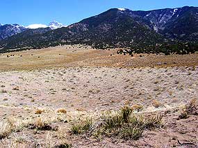
NPS/Patrick Myers Grasslands and Shrublands Spacious grasslands and shrublands are the national park’s least visited area, yet they contain diverse wildlife, migrating dunes, panoramic mountain views, wildflower blooms, and intricate beauty. Sand Sheet Loop Trail: This 1/4 mile (0.5 K) trail from the Visitor Center provides a small glimpse into the grassland ecosystem, with interpretive signs along the loop. In summer, look closely for miniature short–horned lizards among the grasses. Their camouflage resembles the sandy soil, so you may not see one until it moves. Please do not try to pick up this protected species. Trail–less exploration: You may explore on foot for many miles into the park’s grasslands and shrublands from the park entrance road, between the park entrance sign and the Visitor Center. Park at designated pull–outs on the west side of the road. Fences indicate Nature Conservancy boundaries; do not cross any fences without permission. Mid–August is a peak time in wet years to view millions of prairie sunflowers. Pronghorns, kangaroo rats, bullsnakes, short-horned lizards, spadefoots, vesper sparrows, and burrowing owls are common here. North Access to the National Park Access to the grasslands and riparian corridors north of the dunes is possible via public roads. Click "View Park Map" on the menu at left to see access from the north to the Liberty Gate backcountry access parking area. Please stay on public roads through the Baca Grande Subdivision, and respect any private property. From the Liberty Gate, you may hike on the historic Liberty Stage Road, or cross–country away from trails. You may also backpack into this area from the Liberty Gate or via the Sand Ramp Trail. Features of this area include: rolling shrublands and grasslands, large herds of elk, a crater that some geologists believe is meteoric, cottonwood–lined creeks, and stunning views of the Crestone Peaks. Privately Managed Grasslands Within the National Park The Nature Conservancy, in cooperation with Ranchlands, manage historic Medano Ranch lands within park boundaries. About 2000 bison roam these grasslands. There is no public access to Nature Conservancy lands. 
NPS/Patrick Myers Wetlands Creeks that flow off the mountains become part of a large aquifer beneath the valley floor. Low areas of the valley intersect the water table, forming wetlands. Some of these wetlands are on national park lands, while others are on Nature Conservancy lands or nearby public lands. Please make sure you have a good map before exploring, as the wide, flat valley floor and often unpaved roads can be disorienting if you're not familiar with it.
Medano Creek Wetlands: In late spring and early summer when precipitation is average or above average, wetlands form along Medano Creek at the base of the dunes. These may be accessed by hiking down the streambed toward the end of the cottonwood trees. Some of these wetlands are hidden; check with a ranger at the Visitor Center for more details and current conditions. Plains spadefoot tadpoles inhabit these pools in spring and early summer, while birds and garter snakes try to catch them. Wetlands along County Lane 6: During spring runoff in wet years, wetlands may form along this road, the southern border of the national park. Please park off the road, and do not cross any fences onto private property. Interdunal ponds are semi–permanent or permanent features, unexpected oases in the sand. The pond closest to the Visitor Center requires a 6 mile hike over sand. Please contact a ranger for specific directions.
Some of the wetlands within Great Sand Dunes National Park, including Cotton Lake, Dollar Lake, Twin Lakes, Indian Spring, and Little Spring, are currently managed by The Nature Conservancy, and are not to the public. 
NPS/USFWS Photo Wetlands adjacent to the national park San Luis Lakes State Wildlife Area, adjacent to Great Sand Dunes National Park, contains many wetlands open to the public except during nesting season (closed February 15 - July 15). The large lake near the entrance of the wildlife area is open year round; some shore birds and ducks also visit this lake. This is an excellent area to see shore birds, including white–faced ibis, American avocets, night herons, snowy egrets, great blue herons, and countless others. Elk occasionally visit the wetlands, and bear have been sighted here eating trapped fish in dry years. Sandhill cranes roost here in spring and fall. Amphibians thrive in these wetlands, including chorus frogs, three species of toads, and tiger salamanders. Enter the wildlife area 8 miles west of Highway 150 on County Lane 6. A wildlife stamp is required to enter state wildlife areas. This wildlife area is adjacent to the area managed within the national park by The Nature Conservancy; occasionally visitors view herds of bison grazing on Conservancy lands from the safety of the wildlife area. Fences on the east side of the wildlife area indicate Nature Conservancy boundaries; please do not cross without permission.
While many of the wetlands in and near the national park currently have limited access, these described below are generally open to the public. Some of the Blanca Wetlands are almost other–worldly, with wide, shallow lakes surrounded by whitish, alkali salt flats. The deeper, more vegetated lakes are stocked with warm water fish. Some hardy shore birds and amphibians are also found here, along with unusual plants adapted for the salty, wet, sandy soils. Located between Great Sand Dunes and Alamosa, this area is managed by the Bureau of Land Management (BLM). The wetlands are closed for nesting from February 15 - July 15. From Great Sand Dunes, Take State Hwy. 150 south from the park a few miles to County Lane 6. Take Lane 6 west for 15 miles to Highway 17. Turn left (south), and drive to County Road 2S (not 2N). Turn left (west), and take this dirt road about 7 miles to the road's end and entrance to the wetlands. Stop and pick up a wetlands map at the kiosk. Alamosa Wetlands is an open space area protecting wetlands near the Rio Grande, just northeast of Alamosa. Developed with hiking trails and nearby parking, it provides easy access for residents and visitors to Alamosa. Because of this development, less wildlife is generally seen here than at other more remote wetlands. From Highway 17 one mile north of Highway 160, turn west at the Splashland swimming pool. Park along this road in designated lots. National Wildlife Refuges in the San Luis Valley: Alamosa NWR protects wetlands and cottonwood groves along the Rio Grande, 5 miles southeast of Alamosa. Monte Vista NWR, located 10 miles south of Monte Vista, is a complex of irrigated and agricultural wetlands, a haven for sandhill cranes during spring and fall migration. Both refuges harbor a wide variety of birds. Look for brown highway signs for both refuges along Highway 160. Baca NWR, adjacent to Great Sand Dunes National Park, was designated in 2004 and is not yet open to the public. Russell Lakes State Wildlife Area is located in the northern part of the San Luis Valley, 10 miles south of the town of Saguache on Highway 285. At 4,000 acres, it is the largest contiguous wetland area managed by the Colorado Division of Wildlife. As with many wetlands, much of it is closed to the public during nesting season, February 15 - July 15. However, the Johnson Lake Trail is open year–round. |
Last updated: March 31, 2020