|
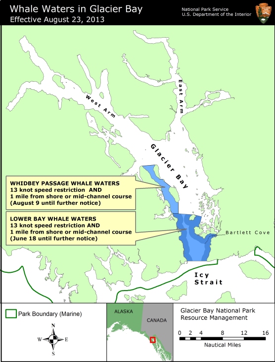
Contact: Albert Faria, Chief Ranger , 907-697-2230 Contact: Chris Gabriele, Whale Biologist, 907-697-2664 Glacier Bay National Park and Preserve Superintendent Susan L. Boudreau announced today that the 13-knot vessel speed limit at the mouth of Glacier Bay will be lifted due to a decrease in the number of humpback whales in the area. This change goes into effect at 5AM Friday August 23. Whale waters in lower Glacier Bay and Whidbey Passage remain unchanged. As shown on the attached map, the existing Whidbey Passage whale waters are defined by the following boundaries:
Also shown on the attached map are existing whale waters in the Lower Bay, which begin at an imaginary line between Pt. Carolus and Pt. Gustavus, extend north to an imaginary line between Lars Island and Strawberry Island, and continue east to the Beardslee Islands motorless waters boundary. Vessels greater than 18 feet in length are restricted to a mid-channel course or one nautical mile offshore in all current whale waters, and for all vessels in whale waters, there is a speed limit of 13 knots through the water. Boaters should proceed cautiously in all areas where whales may be present because whales may surface in unexpected locations, posing a hazard to both the vessel and the whale. Vessels are prohibited from operating within ¼ nautical mile of a humpback whale in Park waters, including those Park waters outside Glacier Bay proper. In addition, vessel operators positioned within ½ nautical mile of a humpback whale are prohibited from altering their course or speed in a manner that results in decreasing the distance between the whale and the vessel. Speed and course restrictions in whale waters are intended to reduce the disruption of feeding humpback whales and to lower the risk of whale/vessel collisions, as authorized by Title 36 of the Code of Federal Regulations, Subpart N, 13.1174. Boaters are advised to verify whale waters designations prior to entering Glacier Bay by telephoning (907) 697-2627 or by contacting KWM20 Bartlett Cove on marine VHF radio. For a printer-friendly PDF version of this news release, please click here. |
Last updated: February 8, 2018