|
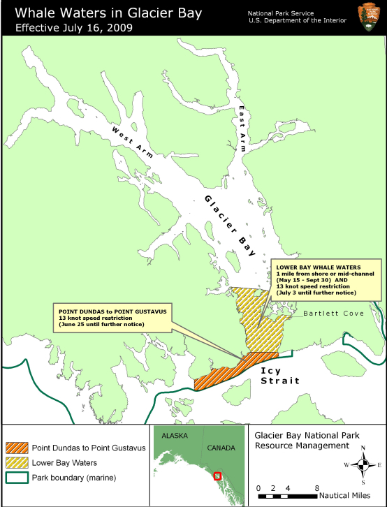
Contact: Allison Banks, Public Information Officer, 907-697-2230 Acting Superintendent Wayne Howell announced today that the 13 knot speed vessel limit at the entrance to the West Arm of Glacier Bay will be removed due to a decrease in the number of whales in this area. On July 3 special whale waters were implemented in the West Arm to protect numerous humpback whales that were frequenting the area. Recently, whales have largely moved out of the area, so the 13 knot speed limit will be removed. However, vessel operators are advised to proceed cautiously in that area, as one or more whales may still be feeding sporadically in mid-channel. This change is effective beginning at 5 AM on Thursday July 16. Speed and course restrictions in whale waters are intended to reduce the disruption of feeding humpback whales and to lower the risk of whale/vessel collisions. Consistent whale monitoring protocols are used to document whale distribution, and adaptive management priniciples are used to define areas need to protect whales. Since July 3, all vessels in Lower Bay whale waters have been restricted to a speed of less than 13 knots through the water, and vessels greater than 18 feet in length have been restricted to a mid-channel course or 1 nautical mile offshore. In addition, since June 25, all vessels transiting outside the mouth of Glacier Bay in Park waters between Point Gustavus and Point Dundas have been restricted to a speed of less than 13 knots through the water. Numerous whales are still using these areas, so restrictions in those areas will continue to be in effect until further notice. The attached map shows the revised location of all whale waters areas in Glacier Bay National Park waters as of July 16, 2009. As shown on the attached map, lower Glacier Bay whale waters include the waters extending from the mouth of Glacier Bay to a line drawn between the northern tip of Strawberry Island and the northern tip of Lars Island. This boundary is shown on NOAA nautical chart 17318 of Glacier Bay. All vessels are restricted to a 13 knot speed limit through the water in this area. Vessels greater than 18 feet in length passing through this area are also restricted to a mid-channel course or 1 nautical mile offshore. Also shown on the attached map, the special whale waters outside the mouth of Glacier Bay from Point Gustavus to Point Dundas are bounded on the north by a line between Point Carolus and Point Gustavus, and on the south by the Park boundary in Icy Strait. The eastern boundary of this area is defined by a line running due south from Point Gustavus to the Park boundary, and the western boundary is a line running due south from Point Dundas to to the Park boundary. All vessels are restricted to a 13 knot speed through the water in this area. Boaters should proceed cautiously in all areas where whales are present because whales may surface in unexpected locations, posing a hazard to both the vessel and the whale. Vessels are prohibited from operating within ¼ nautical mile of a humpback whale in all Park waters, including those Park waters outside Glacier Bay proper. In addition, vessel operators positioned within ½ nautical mile of a humpback whale are prohibited from altering their course or speed in a manner that results in decreasing the distance between the whale and the vessel. Boaters are advised to verify whale waters designations prior to entering Glacier Bay by telephoning (907) 697-2627 or by contacting KWM20 Bartlett Cove on marine VHF radio. Whale waters restrictions are authorized in Glacier Bay National Park in accordance with Title 36 of the Code of Federal Regulations, Subpart N, 13.1174. |
Last updated: April 14, 2015