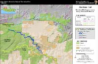
Backbone Trail: Mountain Bike Bypass Around Boney Mountain Wilderness
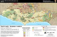
Trail Grade: Steepness Analysis of the Backbone Trail
It’s often the things we take for granted that make our national park vacations so memorable. We may choose a park for its natural features, such as geysers or glaciers, or simply because we want a break from the hustle and bustle of everyday life. As we enjoy nature’s offerings, we may not notice the smooth roads, working restrooms, and safe trails that help form the backbone of the national park system. We tend to take our safety and personal comfort for granted before we set off from a visitor center in search of a bald eagle, or a distant mud pot. Imagine our reaction, then, if we arrived to find a park full of potholed roads, dangerous trails, broken toilets and splintered benches. To make sure that doesn’t happen, national parks use all the tools at their disposal, including the latest in GIS software and other computer programs.
National parks often go to great lengths to provide basic services as such as drinking water and sewers. Some parks capture millions of gallons of rainwater. Others build sophisticated water recycling plants to conserve what little they have. Parks must restore trails and repair buildings in rugged, remote areas far from civilization. Many buildings are more than 50 years old and require special care to protect their architecture and historic significance. To meet these challenges, national parks increasingly use GIS to map the locations of roads, trails, utilities and buildings, along with their condition and need for repair. GIS technology turns reams of complex data into a clear map with many layers, each showing one or more themes. Using GIS maps, park managers can identify and schedule needed repairs and better understand the work and cost involved. In this way, GIS serves the national park mission to protect parklands for our enjoyment and education. And when we don’t have to worry about the condition of roads, trails, and restrooms, we can focus on all the things that make our national park experience so special.
Melanie Beck, Santa Monica Mountains
NRA
Using the Power of a GIS Trail
Inventory
for Trail Planning
The coastal mountains near Los Angeles
widen to meet the curve of the seashore in a patchwork of public and
private
lands that make up the Santa Monica Mountains National Recreation Area.
It joins federal, state, and local park agencies with private preserves
and landowners to protect a diverse Mediterranean ecosystem where
native
peoples once made their homes. Now it is “LA’s backyard” for hiking,
mountain
biking, walking dogs, bird watching, and backpacking along a network of
320 miles of trails and dirt roads. GIS serves as a trail guide of
sorts
for the National Park Service and its partners as they plan the future
of the new 60-mile-long Backbone Trail. Planners studied the condition
of the trail and plotted the information onto GIS maps. The maps
quickly
displayed patterns that might otherwise have gone unnoticed in reams of
data. In this case, GIS maps showed the risk of erosion based on the
steep
trail grade in some places. The information will help trail planners as
they decide whether to limit activity on the trail or even reroute
certain
sections. GIS software produced maps that illustrated the geographic
relationship
between key aspects, or attributes, of the trail. The map of the
Backbone
Trail showed at least 10 attributes, including trail width, trail
activities,
alternate routes, and future planning options to balance trail use with
preservation.
|
Backbone Trail: Mountain Bike Bypass Around Boney Mountain Wilderness |
Trail Grade: Steepness Analysis of the Backbone Trail |
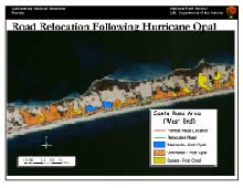
Hurricane Opal demonstrated the power
of
nature when the storm hit Florida’s Santa Rosa Island in 1995.
Sustained
winds of 125 mph and a 15-foot storm surge heavily damaged buildings,
destroyed
roadways, eroded shoreline, razed sand dunes and filled wetlands with
sand
in this part of the Gulf Islands National Seashore. To help document
damage
and rebuild the park, the National Park Service created GIS maps using
ArcView software developed by ESRI, and global positioning system
technology.
GIS helped show how the island literally “rolled over” on itself in the
storm, moving 200 feet closer to the mainland in certain areas, with
the
gulf beach receding by as much as 150 feet. The hurricane gave the park
service the perfect opportunity to re-evaluate the island’s main road,
which had blocked the natural growth and migration of the dunes,
fragmented
their habitat, and disrupted a second dune system. GIS mapping
illustrated
the problem and helped convince the Federal Highway Administration to
relocate
three miles of the seven-mile-long road. The park is also using GIS to
help identify areas prone to storm flooding and damage, and island
features
to avoid during future reconstruction.
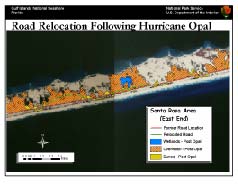 Storm impact map of the eastern end of the Santa Rosa Area showing relocated road sections. |
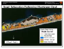 Storm impact map of the middle section of the Santa Rosa Area showing relocated road sections. |
 Storm impact map of the western end of the Santa Rosa Area showing relocated road sections. |
Soaring peaks, lush forests, deep-blue
lakes, glaciers and sculpted mountains make Going-to-the-Sun Road a
spectacular
drive by anyone’s standards. Carved from Montana’s mountainside for
part
of its 50-mile length in Glacier National Park, the road also is an
engineering
marvel threatened by age, weather, poor drainage, and deterioration.
The
road opened in 1933 and needs extensive repairs to avoid the risk of
catastrophic
failure. The National Park Service turned to GIS to help restore the
road
for modern travel without marring the surrounding natural, cultural and
historical resources. The park service created a database to display
themes
of the road on a GIS map. The themes, or map layers, identified
mileposts,
pullouts, guard walls, drainage culverts, survey points, wayside
exhibits,
avalanche chutes, trailheads, retaining walls, and intersecting roads.
The park service linked this information to other databases that
described
the condition of the road and historic guard wall. Developing a GIS
database
with help from GPS software will provide a consistent map to help
engineer
and design repairs and identify cultural and historic items for
preservation.
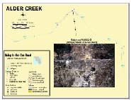 Mapping results at Alder Creek, with image of retaining wall |
 Image of GPS data collection (K. Mich, NPS) during Oct 2000. |
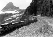 Image (b&w) of Going-to-the-Sun Road circa 1933, shows historic stone masonry guard wall. |
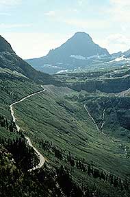 Image of Going-to-the-Sun Road looking towards Logan Pass. |
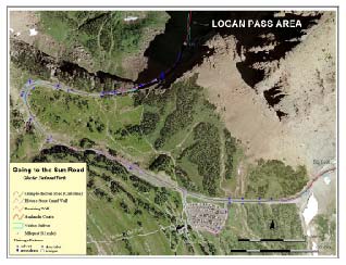 Mapping results at Logan Pass |
The National Park Service wants to capture the knowledge of its veteran maintenance crews and managers by recording what they know about the position of water and sewer lines and other utilities across our national parklands. In the past, people who oversaw park roads, buildings, trails, and campgrounds kept most of the information on paper, or in their heads. Now many of those managers are retiring without leaving current maps. To preserve this valuable knowledge, park service teams are using GPS and GIS technology, first to record the information and then to create maps that show the locations of park utilities. GPS systems accurately record utility locations to one meter, and interviewers can record a worker’s comments about things like pipe length, width, and when the park installed or fixed it. Maintenance crews check resulting GIS maps for accuracy and make additional notes as needed. Examples of success so far include Aztec Ruins National Monument, Fort Union National Monument, and Salinas Pueblo National Monument in New Mexico; Casa Grande Ruins National Monument in Arizona; and Hovenweep National Monument in Utah.
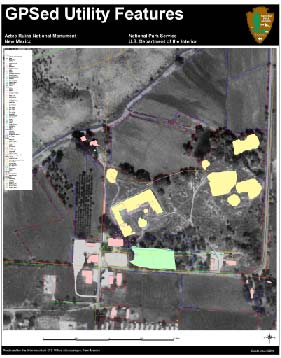 Aztec Ruins utility features |
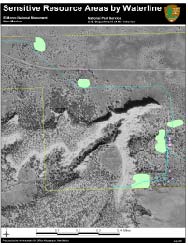 The waterline at El Morro overlaid with sensitive resource areas. Staff was working on the waterline and needed to know the sensitive areas. |
 The GPS crew at Fort Union |
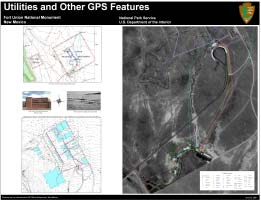 Fort Union utility features |