|
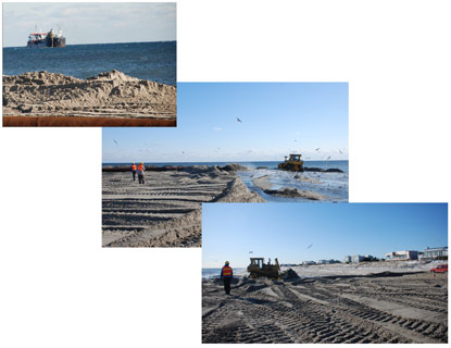
Contact: Mike Bilecki, 631-687-4760 Contact: Paula Valentine, 631-687-4759 Patchogue, New York — Special use permits for the 2008-2009 Fire Island Community Short-term Storm Protection beach nourishment project have been extended through April 25, 2009. Most of the project, which began on Fire Island in late January, was able to be completed by the projected deadline of March 31. A short extension of the window for dredging and sand placement was approved by Chris Soller, Superintendent of Fire Island National Seashore, after consultation with the National Marine Fisheries Service and U. S. Fish and Wildlife Service. The remaining portions of the project will be completed and all equipment and debris will be removed from Fire Island beaches by the end of April. A simultaneous short-term beach nourishment project undertaken by Smith Point County Park, which started in December, 2008, was able to be completed by the end of March. The project for the Fire Island communities started later. Those sections that have already been completed include the beach in front of the communities of Saltaire through Lonelyville, Davis Park, and Fire Island Pines. Equipment will continue to work from east to west as the beach is bolstered in front of the central Fire Island communities between Ocean Bay Park and Cornielle Estates. The Fire Island communities and Smith Point County Park lie within the boundaries of Fire Island National Seashore. Therefore, the National Park Service (NPS) has been involved in the review and approval of these projects including mitigation requirements to address endangered species and other resources. For more information about this project, contact Fire Island National Seashore's Chief of Resources Management Michael Bilecki at 631-687-4760. # # # |
Last updated: March 2, 2018