| .
|
|
Glacier Basics
This page was written to familiarize visitors to this site with what glaciers are, how they behave, how they shape landscapes, and how they are impacted by climate change. In addition to the words and images on this page, you can also access a series of interactive animations and graphics that allow you to "see" the processes and structures described below. These information modules are written in Adobe Flash so your web browser will need to be have a plug-in for Flash 7 or higher. Fortunately most computers and web browsers come with this player already installed. If your web browser doesn't read these files you can download a player free of charge at < http://www.adobe.com/products/flashplayer/
>.
What is a glacier?
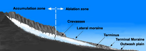
A glacier is a perennial mass of snow or ice that is large enough and heavy enough to flow, like a very thick fluid. Glaciers form wherever more snow accumulates than is lost each year. As new snow accumulates, it buries and compresses the old snow. Under the weight of the overlying snow, the old snow is transformed from a fluffy mass of ice crystals into dense, hard ice. This process occurs on the upper part of a glacier, at higher altitudes, where more snow accumulates than is lost each year. This is called the “accumulation zone”, and is typically covered with snow year-round. The glacier is in constant motion, and the ice in the accumulation zone flows down to lower altitudes, which is called the “ablation zone”. The ablation zone is located in the lower part of the the glacier where more snow is lost than accumulates. In late summer, when the seasonal snow has melted, the bare ice of the ablation zone is exposed.
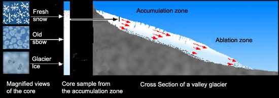
Figure 1 - Cross section of an alpine glacier showing snow being converted into glacier ice (the left side of the figure) and the two major zones of a glacier’s surface. The red arrows show the direction and relative speed of different parts of the glacier. The longer the arrow, the faster ice is moving.
•• Return to the top of the page ••
The anatomy of a glacier
Essentially all glaciers have accumulation and ablation zones. The boundary between these zones, the equilibrium line, is the transition where accumulation equals ablation.
The accumulation zone has three major layers. The top layer is seasonal snow that thickens further up glacier. The next layer is the “firn”, or a transitional form between the snow and solid ice below. The bottom layer is ice. The ablation zone, on the other hand, is composed entirely of ice. During the winter, the ice of the ablation zone is covered with snow, which entirely melts away in summer.
Because the glaciers in Rocky Mountain National Park are so small, it is common for the equilibrium line to be completely above or completely below the entire glacier in a given year. In a cool year, the accumulation zone may cover the entire glacier, and in a warm year the ablation zone may cover the entire glacier. For larger glaciers in equilibrium with climate the accumulation zone typically covers about 65% of the glacier.

- Tyndall Glacier 1940 – almost entire glacier surface is ice
- (Photo: Nesbit)
|
|
- Tyndall Glacier 2000 – upper half of glacier surface is snow. The large dark patch in the middle of the glacier is dirty snow, not ice
- (Photo: R.B. Scott)
|
|

- Tyndall Glacier 1947 – entire glacier surface is snow
- (Photo: J.H. Heger)
|
|
|
|
|
|
|
Figure 2 – Variation of the accumulation and ablation zones on Tyndall Glacier.
|
•• Return to the top of the page ••
Types of glaciers
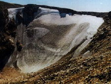
All of the glaciers at Rocky Mountain National Park are cirque glaciers. A cirque glacier is a small glacier that occupies a bowl-shaped basin at the head of a mountain valley. Cirque glaciers are usually the remnants of much larger valley glaciers. Andrews, Tyndall, and Rowe are all good examples of small cirque glaciers.
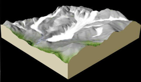
Valley glaciers are glaciers confined to a valley (usually a former stream valley). There are no valley glaciers in RMNP today, but 15,000 years ago many of the valleys in the park were filled with ice. Glacier Gorge, Loch Vale, Chaos Canyon, Glacier Basin, and Forest Canyon are all good examples of valleys formerly filled by valley glaciers. Small ice caps breached the ridge tops at La Poudre Pass and Mummy Pass. An ice cap is a dome-like body of ice that flows out in all directions and has an area that is less than 50,000 square kilometers (10 million acres). Valley glaciers are commonly found in Washington and Alaska.
The largest type of glacier is a continental ice sheet, that can cover thousands of square kilometers. Only two ice sheets of this type exist on the planet today, one on Greenland, the other in Antarctica. During the Pleistocene Ice Age, ice sheets covered nearly all of Canada reaching down into the northern contiguous United States.
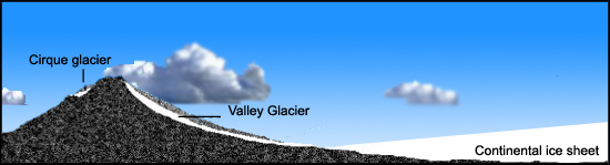
Figure 3 - Three principle types of glaciers
•• Return to the top of the page ••
Glaciers and glacier-like features in Rocky Mountain National Park
As mentioned above, the only type of glacier present today in RMNP are cirque glaciers. However, RMNP is a good place to observe many other snow and ice features. All of these features are easiest to identify at the end of the summer after all of the seasonal snow has melted away.
Cirque glacier: glacier that resides in basins or amphitheaters near ridge crests; most cirque glaciers have a characteristic circular shape, with their width as wide or wider than their length.
Perennial snowfield: relatively small area of snow cover that persists on the ground year after year and does not flow significantly. Perennial snowfields exist in many places in the park, but conclusively identifying which snowfields are perennial is difficult. Snow that exists through multiple summers will eventually form ice. Many apparent snowfields may have massive ice under a thin snow cover. Other snowfields may persist for a few years before disappearing in a particularly warm year. However, it is likely that a new snowfield may reform in the same location in a future cool year.
Buried ice: Ice covered by thick layers of rock and sediment.
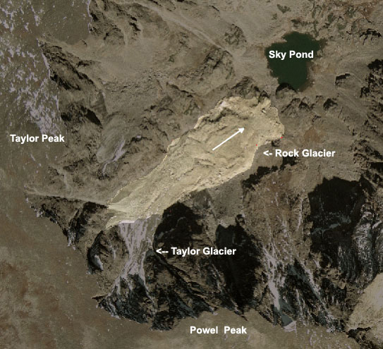
Rock glacier: A large mass of rock that actively flows like a glacier. Boreholes drilled in rock glaciers have revealed primarily a mixture of ice and rock (1). Many scientists consider rock glaciers a form of permafrost, but other researchers believe some rock glaciers may form from small glaciers being covered by rock debris (2). In any case, these complex mixtures of ice and rock flow downhill at speeds up to 1-2 m/year. Rock glaciers in RMNP have been clocked at 13-20 cm/year (3). While rock glaciers have a characteristic glacier-like or lava-like appearance from the air, they can be hard to recognize on the ground, as they look like nothing more than a rock field or talus slope. Rock glaciers exist below Taylor and Tyndall glaciers, as well as in many other locations without glaciers. If you visit them, take care, because the surfaces of rock glaciers are extremely unstable.
|
| Figure 4 – A rock glacier located below Taylor and Powell Peak in Central RMNP. The glacier is flowing out from the base of Taylor Glacier toward Sky Pond. |
Additional information about glaciers and glacier-like features
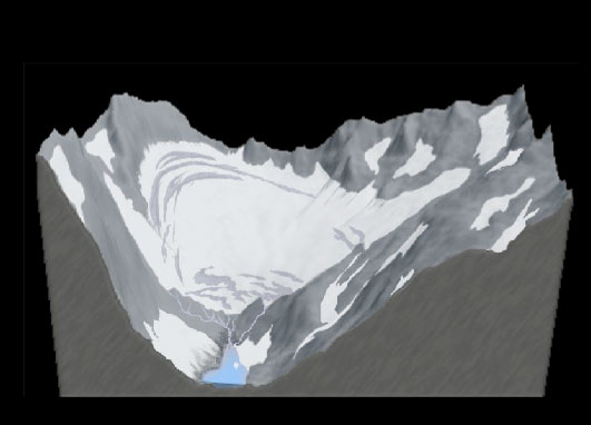
- Glaciers and periglacial features
- This module is a catalog of the types of glaciers and glacier-like features in Rocky Mountain National park. Click on the image on the right to access the module
|
|
•• Return to the top of the page ••
Glaciers and Climate
Climate is the “average weather” in a location. Though climate actually refers to the entire state of the atmospheric system, it is commonly described by temperature or precipitation. Climate determines how much snow a glacier receives and how fast it melts. The part of the year when glaciers gain more ice than they lose is called the accumulation season. In Colorado, the accumulation season is usually from October to May. The part of the year when glaciers lose more ice than they gain is the ablation season, generally from June through September. During a cool, wet year, glaciers gain more snow than they lose, causing the glacier to thicken, and subsequently, advance. During warm, dry years, they melt more snow and ice than they receive, causing them to retreat.
Although glaciers always flow downhill, the idea of glacier “retreat” may give the impression that a glacier can move uphill. In fact, a glacier is in retreat when the rate of movement downhill cannot keep up with the rate of melting. The glacier is melting back faster than it is moving downhill, so it is said to “retreat”. By contrast, when a glacier advances, its downhill flow is greater than the melt at the terminus.
The rate of glacier response has to do with the volume of the glacier and the rate of mass exchange (accumulation and ablation of snow and ice). For example, for the same size glacier, small rates of mass exchange (like glaciers in polar regions) result in slow responses and high rates (like glaciers in the U.S.) cause fast responses. Smaller glaciers response more quickly than larger glaciers. The position, orientation, or elevation of a glacier affects the magnitude of glacier change in response to climate.
Because of their small size, glaciers at RMNP are very sensitive to fluctuations in temperature and respond quickly to warming or cooling. However, due to the locations of the basins in which they reside, most of their accumulation is due to the redistribution of snow by wind or by avalanching, and the accumulation rates on the glaciers can be many times higher than the seasonal snowfall. Because of this, the glaciers are relatively insensitive to variations in snowfall. Variations in glacier mass are caused by changes in summer temperatures from year to year, and perhaps changes in summer cloud cover. Annual measurements in the changes of the mass of Andrews Glacier can be related directly to summer temperature. Warmer summer temperatures melt more ice than cooler summer (4).
The glaciers at RMNP retreated during the first half of the twentieth century as a response to warming at the end of the Little Ice Age (a minor ice age extending from the 16th to the mid 19th century). Many of the glaciers reached a minimum size during the mid-1940s, and fluctuated around a slightly larger size during the 1950s and 1960s. They advanced somewhat through the 1970s and 1980s due to cooler summer temperatures. However since the 1990s almost all glaciers in RMNP have shown a retreat due to high rates of increasing summer temperatures, some shrinking past their historic minimum sizes from the 1940s (4). This pattern of twentieth century fluctuations in mass is similar to that seen by glaciers across North America and globally (5).
Additional information about the connections between glaciers and climate
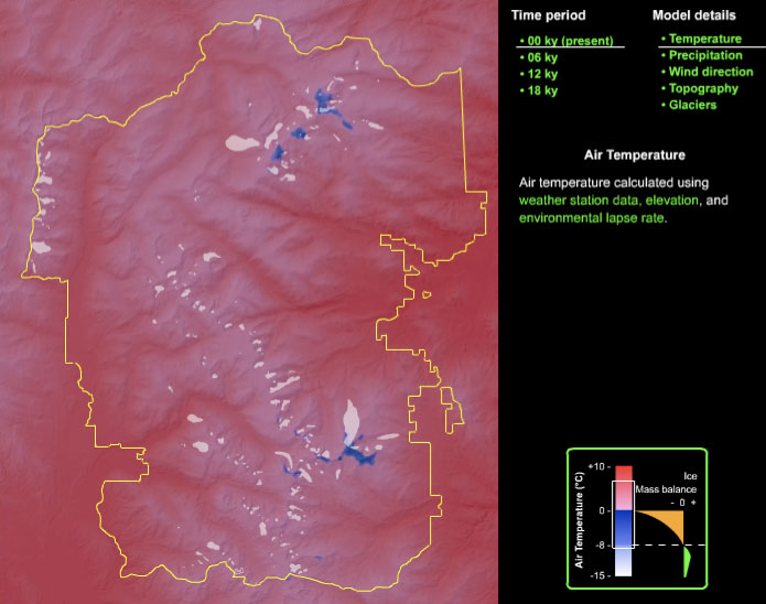
- Glaciers and climate
- This module includes a simple model of climate change since the last ice age to explain the link between climate and glacier response. Click on the image on the right to access the module
|
|
•• Return to the top of the page ••
Ice Ages are periods of time when continental ice sheets expanded to cover large areas of the earth’s surface. The term can be used to describe long periods of time (millions of years) during which glaciers expanded and retreated during a generally cool period of Earth history. In this sense the Pleistocene Epoch (1.8 million to 11,680 years ago) is the most recent major Ice Age. The earliest known Ice Ages occurred 800 to 600 million years ago when snow and ice covered the entire planet (Snowball Earth), between 460 and 430 million years ago, and from 350 to 250 million years ago.
Glaciations are single periods of advance where ice sheets reach their maximum extent. There have been at least 6 major glaciations in the last 700,000 years alone, each one lasting up to tens of thousands of years. The most recent glaciation lasted from 70,000 to 10,000 years ago (called the Wisconsin in North America). The presence of till (unsorted debris carried by glaciers), glacial striations, erratics (large boulders deposited by glaciers), and glacial landforms are all used to identify the extent of recent glaciations. A more complete record of the Earth’s climate history has been reconstructed from ice and ocean sediment cores. Gas concentrations and isotope data from these cores reveal the timing and duration of the cool periods that allowed ice sheets to advance and the warm “interglacial periods” that caused their retreat.
Only the last two glaciations are well documented in North America. The most recent glaciation (the Wisconsin) saw continental ice sheets reach as far south as Wisconsin and Seattle. In the Rocky Mountains this glaciation is called the Pinedale glaciation, named after the town next to the Wind River Mountains of Wyoming where evidence for it was first documented. No large ice sheets existed in the Rocky Mountains, but several small ice sheets (ice caps) and large valley glaciers existed in many ranges and an ice sheet covered the peaks of the Wind River Range. In the Front Range valley glaciers were up to 45 km long, and a small ice sheet formed at the headwaters of the Cache la Poudre River (6). The previous glaciation occurred about 120,000 years ago, and is called the Illinoian in North America, for it reached as far south as southern Illinois. There were no ice sheets in the southern Rocky Mountains at this time either, but valley glaciers reached a slightly further extent – about 1-1.5 km further down valley in the Front Range. In the Rockies this glaciation is referred to as the Bull Lake glaciation, again after a locality in the Wind River Range. Previous glaciations advanced as far south as Nebraska in North America, but evidence in the Rocky Mountains is difficult to identify. In addition to these large glaciations, at least 3 minor advances (termed “neoglaciation”) have been identified in the Front Range since the end of the Pinedale glaciation. These neoglaciations have occurred in the last 5,000 years and have been restricted to within 2.5 – 4 km of the cirque headwalls (6).
Additional information about ice ages
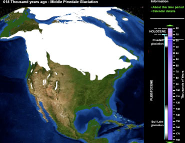
- Ice ages of North America
- This module shows glacier change for all of North America during the past 180,000 years.
- Click on the image on the right to access the module
|
|
•• Return to the top of the page ••
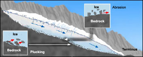
Much of the landscape of RMNP has been shaped by the continuous growth, disappearance, and regrowth of glaciers in the park. In the high mountains these glaciers have carved deep valleys and numerous small basins, while In the lower altitudes they have left a variety of small hills and ridges whenever they have receded. At all altitudes they rerouted streams and created numerous lakes and ponds.
Glaciers carve landscapes in two ways. First, they pluck rocks from bedrock by either freezing on to it or by ripping rocks from subglacial ledges. The plucked rocks are dragged by the moving ice over the rock remaining in place. The rock studded ice acts like sandpaper to grind bedrock. While glaciers have deeply eroded many valleys, many ridge tops have been unaffected. The contrast between the deeply eroded valleys and cirques and the rolling, unglaciated ridge tops can be appreciated from Trail Ridge Road or on the trail up to Flattop Mountain.
In addition to eroding bedrock, glaciers landscape the terrain by depositing rocks into ridges called moraines. One of the best places to see well developed terminal and lateral moraines is at Moraine Park and Glacier Basin. Good places to see the after-effects of plucking and abrasion are in the many valleys near Bear Lake, where exposed bedrock reveals plucked knobs and striated rock. One such rock knob, called a roche moutonnée, can be seen in the middle of Moraine Park from the Moraine Park Visitor Center.
|
|
| Figure 5 - A cross section of a glacier showing plucking and abrasion. |
Rock debris covers the ablation zone of some existing glaciers at RMNP. Rocks fall from the valley walls directly onto the glacier and then are carried down valley by the glacier. Eventually the rock is deposited at the end or along the sides of the glacier forming moraines. Moraines that form on the side of a glacier are called lateral moraine, while those that form at that end of a glacier are called terminal moraines. Mapping moraines is an important step in determining the size of glaciers during earlier, colder times. Old lateral and terminal moraines are found throughout RMNP.
|
|
| Figure 6 - A cross section of a typical alpine glacier showing the location of lateral and terminal moraines. |
Additional information about glaciers as landscapers
- Glaciers and landscapes
- Much of the landscape of Rocky Mountain National Park is the result of Pleistocene glaciers. This module shows how these glaciers did so and the landforms that they left behind.
- Click on the image on the right to access the module
|
|
•• Return to the top of the page ••
References cited on this page
- Clark, D. H., E. J. Steig, N. Potter, Jr., J. J. Fitzpatrick, A. B. Updike and G. M. Clark. 1996. Old ice in rock glaciers may provide long-term climate records. Eos, Transactions, American Geophysical Union, 77(23), 217, 221-222.
- Whalley, W. B. and F. Azizi. 2003. Rock glaciers and protalus landforms: Analogous forms and ice sources on Earth and Mars. Journal of Geophysical Research E: Planets, 108(4), GDS 13-1 - 13-17.
- White, S.E. 1971. Rock glacier studies in the Colorado Front Range, 1961-1968. Arctic and Alpine Research, 3, 1, 43-64.
- Hoffman, M.J., Fountain, A.G., Achuff, J.M. 2005. Twentieth-century variations in area of small glaciers and icefields, Rocky Mountain National Park, Rocky Mountains, Colorado, USA. Annals of Glaciology, Accepted.
- Dyurgerov, M.B. and Meier, M.F. 2000. Twentieth century climate change: Evidence from small glaciers. Proceedings of the National Academies of Science 97, 4, 1406-1411.
- Madole, R.F. 1976. Glacial geology of the Front Range, Colorado. in Mahaney, W.C. (ed.) Quaternary Stratigraphy of North America, Stroudsburg, Pa.: Dowden, Hutchinson & Ross.
•• Return to the top of the page ••
|
|
, |
|