|
Baseline Research >> Current Page
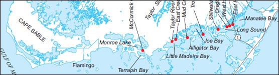
Image Courtesy of Hittle, Patino & Zucker Historically, seasonal flows of freshwater coursed south from the terrestrial Everglades, draining into Florida Bay via a network of coastal estuarine creeks. These periodic infusions of freshwater remain critical for the health of the our coastal systems, and restoring such flows remains a high priority in the effort to save the remnant Everglades. Reaching this goal, however, requires the availability of reliable baseline data. This CESI-funded project monitors the magnitude and distribution of freshwater flows through nine estuarine creeks within the mangrove zone along northeast Florida Bay-- an area where information on flow, salinity, and water-level was previously unavailable. Data collected from this study can be utilized in model development and calibration, and helps illuminate the dynamics behind the Everglades/Florida Bay transition zone. To view a copy of the report please contact us
Contact the principal investigator directly with questions about this study.
Northeastern, Florida Bay, Freshwater, Flow, Estuary, Creeks, Hydrology, Salinity, Hittle, Patino, Zucker, CESI, Everglades, National Park, Critical Ecosystem Studies Initiative
|

Last updated: June 23, 2021