|
CESI >> Program Areas & Projects >> Baseline Research >> Current Page
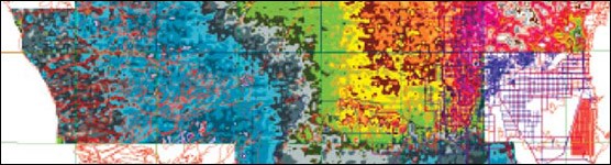
Image Courtesy of the USGS Continuous shallow surface water flow, also known as sheetflow, is largely dependent on land surface elevation. This project created two high-accuracy elevation maps that provide elevation data of sufficient accuracy to assist hydrologic modeling of sheetflow. Modeling sheetflow and water surface levels in the Everglades wetlands has proven difficult due to the large expanse of the area and the extremely low relief of the terrain. Collection of global positioning system (GPS) points used the helicopter-based Airborne Height Finder System developed by the U.S. Geological Survey. Additional elevation data were acquired through contract professional surveying services. The first map created was two-dimensional with elevations realistically proportioned. The second map was three-dimensional with elevations exaggerated 500 times to allow for easier interpretation of the extreme low slope (6 inches per mile) of the Everglades topography. FOR DOWNLOAD 
Fact Sheet Contact the principal investigator directly with questions about this study. Measuring, Mapping, Topography, Florida, Everglades, Ecosystem, Restoration, CESI, Critical Ecosystem Studies Initiative, Desmond |

Last updated: October 3, 2018