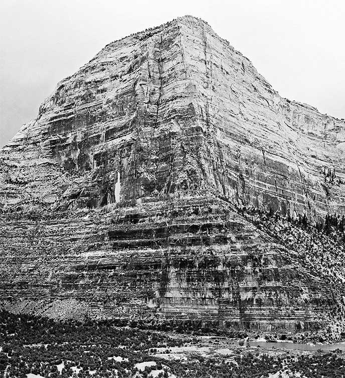
NPS/George A. Grant The Warm Springs Rapid that today's river runners know is mostly the product of the huge debris flow that occurred in 1965. Since then the rapid has provided a thrilling ride near the end of an otherwise relatively moderate whitewater river canyon. At higher water Warm Spring's hydraulics can be terrifying. At lower levels precise boating skills are still required to gracefully negotiate the run. It is not unusual for river runners to spend the early days of a Yampa trip trying to enjoy the canyon's spectacular scenery, all the while quietly entertaining a nervous question-what will Warm Springs be like this time? The look and feel of the rapid varies with each change in river flows, and scouting is always the norm, even for those who have run Warm Springs many times before. In the summer of 2012 a large rock fall from Warm Springs Cliff significantly changed the topography at the top of the rapid, and there has been much speculation and trepidation in the months since about what these changes will bring for the next boating season. After news of the rock fall spread in early August 2012, a surprising number of people were motivated to hike in from Echo Park to inspect the results for themselves. The consensus seems to be that the changes will make the rapid more difficult, but until the water comes up in the spring we cannot really know. Certainly river runners should approach the rapid with great caution in the future-just as they have in the past. This page provides a brief description and some photographic documentation of what happened at Warm Springs last summer. Hopefully boaters who weren't able to make the journey to the rapid to take a look themselves can now see what all the speculation has been about. 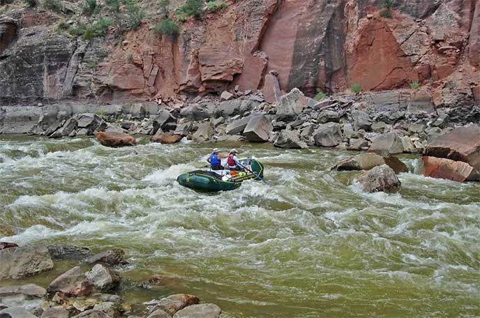
NPS/Peter Williams The Rock Fall The source of the rock fall can be clearly seen roughly half way up the 1,700-foot-high cliff face, and for weeks afterward a telltale trail of dust led downward to the destruction below. The falling slabs quickly hit ledges high on the cliff and shattered. The finer material fell straight down into a pile against the base of the cliff, while the larger blocks bounced outward and landed in the middle of the river channel. The majority of the blocks are piled in a remarkably small area, although a few strays landed farther away. Just on the upstream side of the pile of blocks is an obvious impact crater, perhaps 20 feet or more in diameter. It is possible that a single very large block hit here and bounced in a downstream direction while shattering-this would explain why there's nothing presently in the crater big enough to have created such a large feature, and why the majority of the blocks are piled close by. The impact of the rock fall created a tremendous blast, which is recorded in the many box elders shattered along the right bank of the rapid. It must also have created an enormous splash. The Yampa was flowing at roughly 200 cubic feet per second at the time, so the water's edge would have been right about where the impact occurred. Apparently the force of the impact was great enough to send ripples through the saturated river bed, liquefying the mix of water and sediments surrounding the river cobbles into a thick goop, and rearranging many of the smaller boulders in the vicinity. A wave of the silty mud mixture appears to have traveled outwards from the impact zone, coating the vertical faces of the larger boulders in the area. A distinct high water mark in the mud on the boulders in the river may have come from several small, short-lived increases in river flows in mid July. The huge splash also coated trees and shrubs on shore, with splatters of mud landing hundreds of feet away. An informal report written soon after the rock fall was discovered by National Park Service employees suggested that there may also have been a small debris flow just prior to the event. Further investigations have confirmed that this was in error. Although significant debris flows did occur at Warm Springs Rapid in 2010 and 2011, none appear to have occurred there in the summer of 2012. Pulverized debris 
NPS/Peter Williams A: The "upside-down coke bottle" scar, prominently in view during the last mile-long stretch of river as boaters approach the rapid. This was probably the source of a rock fall in the early 1960s, depositing the large boulders on river left at the head of the rapid. B: An older rock fall scar, visible in the 1935 photograph of Warm Springs Cliff taken by National Park Service photographer George A. Grant. C: The source of the 2012 rock fall. D: This scar is on ledges, and appears to have been the result of impacts from the blocks falling from C. Some blocks may also have been knocked loose from this section, but its principal contribution to the event was probably the shattering of material falling from above. E: This area appears as a very prominent long, narrow, light-colored rock scar in the 1935 photograph of the cliff, suggesting that it had been the most recent rock fall at that time. It now shows a much more advanced stage of weathering compared to B, perhaps because it is in a less sheltered position. The older scar just above and right of it is also visible in the 1935 photograph. F: The area impacted by the 2012 rock fall. 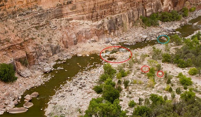
NPS/Peter Williams The Rapid 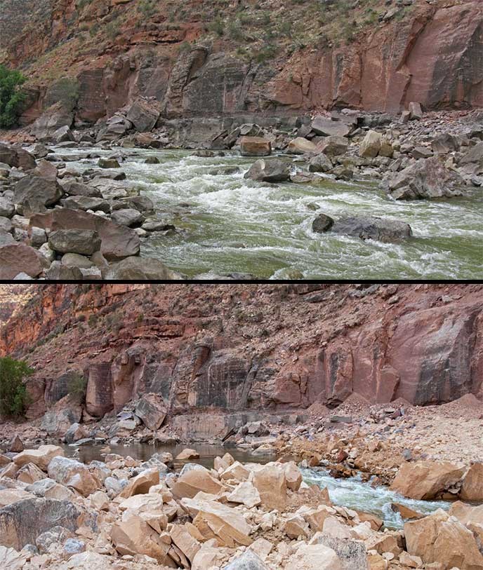
NPS/Peter Williams |
Last updated: December 19, 2017