|
NPS Image
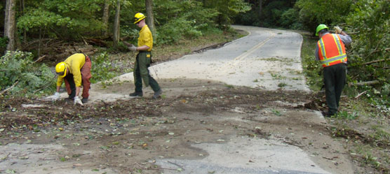
Contact: Deb Nordeen Superintendent John Donahue announced today that Hurricane Irene left widespread damage throughout Delaware Water Gap National Recreation Area. Strong winds downed trees and power lines making roads and trails impassable in both the Pennsylvania and New Jersey portions of the park. Fast moving streams overtopped roads, undermined road surfaces and shoulders, inundated trail bridges, and flooded park buildings. The Delaware River crested yesterday, causing minor flooding and washing over low-lying sections of U.S. Route 209. The majority of park buildings and residences are without electrical power. Park staff are performing initial damage assessment and clean up operations throughout the 70,000 acre park. Sawyers from the park and from the Upper Delaware Scenic and Recreational River are hard at work removing downed vegetation blocking primary roads and trails. Two four-person trail crews are en-route from Acadia National Park and Shenandoah National Park to help with the cleanup effort. Additional National Park Service personnel have been assigned to prepare a comprehensive, accurate assessment of damage to all park roads, facilities, and archeological, natural, and cultural resources. Closures remain in effect throughout Delaware Water Gap National Recreation Area while damage assessments and cleanup operations get underway. Extensive closures to park roads and facilities, are expected to continue through the Labor Day weekend, therefore visitors should plan accordingly. Swim beaches and other visitor facilities are not likely to be open this weekend. Reopening is hampered by the need to have power lines removed from park roads. Restoration of electrical power is not expected until midnight on Friday, making repairs difficult at best. The current status of Delaware River access, roads, trails, and visitor use areas follows. Delaware River/ Canoe and Boat Access Ramps The Delaware River and all river access points from Milford to Delaware Water Gap remain closed to all recreational activities until the river recedes to a safe level. The Delaware River gauge at Montague, New Jersey currently reads 14 feet, down from a crest of 21.94 feet yesterday morning, several feet below flood stage of 25 feet. In the south end of the park, the Tocks Island gauge is at 15 feet; it crested yesterday afternoon at 23.21 feet, two feet above flood stage. National Weather Service forecasters predict a steady decline in river height over the next several days. Roads Road closures continue in the park as crews remove trees and debris and assess damage to road surfaces, shoulders and bridges. Pennsylvania
New Jersey
Visitor Centers
Millbrook Village is closed. Flooding from Van Campens Brook caused extensive damage in the village. Camping Areas
Recreation Areas
Trails
For updated information on the status of park facilities, roads, and trails, call park headquarters on weekdays (570-426-2452). Updated information is also available on the park's website, www.nps.gov/dewa, on www.facebook.com/DelWaterGapNPS, and www.twitter.com/DelWaterGapNPS. |
Last updated: April 14, 2015