|
UNIT 70 Description: This unit cuts across the lower reaches of several major rivers that flow down from the Alaska Range to the north. In between these river corridors are large areas of muskeg, forest and dense brush. There is high, open ground with alpine tundra vegetation in the extreme northeast corner of the unit between Windy Creek and Cantwell Creek. The Dunkle Mine area is also contained within this unit above Costello Creek. 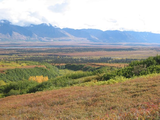
nps photo Tips/Special Features: Compared to the rest of the south side of Denali National Park, this area is relatively accessible because of its proximity to Highway 3. Most people backpacking in this unit pass through on their way into the Wilderness areas of the park. Experienced pack rafters will find many rivers to float in this area, but be aware of public access issues when you leave the park. Access: Even though this unit is close to Highway 3, it is a challenge to reach it due to the dense brush and limited public access routes. Before attempting to enter this unit, contact the Backcountry Information Center for current information on public easement trails. Most of the land between the Highway and the National Park is owned by AHTNA, Inc., an Alaska Native Corporation and a permit fee is required for all public and commercial activities, including hiking. The extreme northeastern end of the unit can be reached by following an ORV trail from the town of Cantwell (See Unit 16 description for more details). The middle part of the unit and Cantwell Creek is accessible from a public easement ORV trail near the Summit Airstrip. The “Dunkle Mine Road” is the primary access route for the southern portion of the unit and the Dunkle Hills. It leaves Hwy 3 at milepost 187.5 and passes through the community of Colorado. Vehicle use of the road is restricted at its crossing of the Alaska Railroad at Colorado. There are 3 main alternatives if the objective is to travel through this unit to reach the Wilderness area of Denali. You can reach the headwaters of the Bull River and Easy Pass (Unit 17) from the end of the Dunkle Hills road. There is a major stream crossing on this route at the Bull River that may not be passable on foot for most of the summer. Crossings can be reliably done with either a pack raft. The road eventually reaches the edge of alpine tundra between the West Fork of the Chulitna River and the Bull River. Getting to the Bull River gravel bar from this location requires at least a day of hiking across wet sedge meadows and brushy hillsides. The upper part of the Bull River is an open gravel bar so travel is relatively straightforward once it is reached. The Bull River south of the Wilderness boundary goes into a steep canyon and is very dangerous for rafters and hikers. The West Fork of the Chulitna is the primary access corridor for travel over Anderson Pass (Unit 23). This is an extremely large river and it can be reached by following the Dunkle Mine Road to where the Bull River comes into it. The West Fork has a large open gravel bar in many areas, but it also runs up against cliffs at the edge of the valley along the route to the glaciers. Getting by these can require a mile or more of climbing up several hundred feet through dense alder thickets. A pack raft is recommended for this area, but should only be used by experienced rafters due to the size of the West Fork. Traveling along Cantwell Creek from the Park boundary to the Wilderness boundary (Unit 17) is brushy at first and then becomes much better as the gravel bar becomes less vegetated and wider. There is good camping on the river bar as you go farther upstream. Shorter trips are possible on the alpine ridge systems in the northeast portion of the unit and these can be accessed from the town of Cantwell and it’s public easement routes. Additional Notes and/or Hazards: Hiker contemplating trips into or through this unit should contact the Backcountry Information Center for more specific directions. For information and maps regarding AHNTA land and its regulations, look on their website at www.ahtna-inc.com. 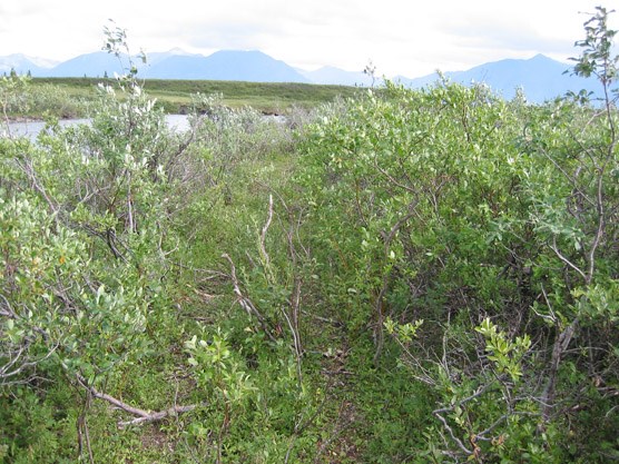
nps photo |
Last updated: April 14, 2015