|
Driving Directions Take Exit 3 from Interstate 95. At the exit stop light turn east on to Highway 40. Follow the signs traveling east into Historic St. Marys. Highway 40 East will also be named Osborne St. Once you reach the historic district, turn right at the stop sign onto St Marys Street. The NPS visitor Center is in the blue building and the Ferry dock are both located on the left. For GPS Users: try the following address: 113 St. Marys Street St Marys, GA 31558. This is our visitor center address and will get you to the right location. If you simply put in Cumberland Island National Seashore, your GPS unit will likely take you to Crooked River State Park as this is the closest boat ramp to the Seashore. 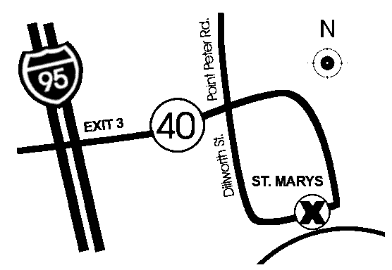
Parking Lot Cumberland Island Visitor Parking
Live Status
All visitors to Cumberland Island should park in the lot one block west of the Mainland Visitor Center. The tree covered lot is located on the block between Wheeler St. and Seagrove St., behind the park headquarters building. There are two entrances along St. Marys Street and one entrance along Stable Alley.
Bus, RV, and over sized parking spaces are located along Seagrove Street.
Cumberland Island Visitor Parking Visitor parking is free of charge. Cost: $0.00
Image Gallery
Transportation to the Island The only way to get to the island is by passenger ferry (not a car ferry) or private boat. For information about making a reservation with the National Park Service official concessionaire operated ferry visit our Reservations page or visit Cumberland Island Ferry website. Cumberland Island is only accessible by ferry or private boat. These directions are to the mainland visitor center in St. Marys, GA. Driving Directions To reach the visitor center from Interstate 95: • Take Exit 3 for US 40 • Take US 40 East toward “Historic Downtown St. Marys” • US 40 becomes Osborne Rd. Continue on until you reach the waterfront • Turn right on St. Marys Rd • The visitor center will be two blocks down on your left (113 St. Marys St W, St Marys GA 31558) |
Last updated: March 19, 2026