Citizen Science

Chronolog Time-Lapse Project

Anyone can be a citizen scientist! Use your phone to help us record changes in the environment while you explore the preserve.
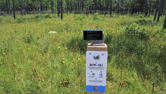
The project features photo stations in three essential ecosystems of the Big Thicket: wetland pine savannah, cypress tupelo slough, and longleaf pine forest. By taking photos at these locations, and sending them to the Chronolog website, you can contribute to a long-term study to understand how the Big Thicket changes over the seasons and years. The site stitches together the photos to create a time-lapse that shows changes over time. Everyone is invited to participate!

How it works

  • Step 1: Find a photo station (see below for list of locations)
  • Step 2: Mount your phone on the bracket and take a photo
  • Step 3: Email the photo to Chronolog using the information provided at each station
  • Step 4: Check the Chronolog website and watch a time-lapse of everyone’s photos

 
cell phone sitting in a custom photo bracket above a green meadow
Pitcher plant bog in late summer

NPS Photo / Scott Sharaga

Photo Station #1
Pitcher Plant Trail

Lat./Long. Coordinates: 30.585109, -94.336857
► Watch the time-lapse

The Pitcher Plant Trail is home to a large bog full of carnivorous pitcher plants in spring and summer. These unusual plants use nectar to attract insects. Once inside the funnel, the insect is trapped and the pitcher plant uses its digestive fluids to consume the insect. Dramatic changes to the bog happen in spring as new pitchers begin to grow, and in fall, as the plants turn brown before dying.

Find the photo station along the wooden boardwalk that leads through the pitcher plant bog. Read more about the Pitcher Plant Trail


cell phone sitting in a custom photo bracket on a wooden bridge, facing a dry swamp in the forest
Station #2 sits on a bridge over a cypress tupelo slough.

NPS Photo / Scott Sharaga

Photo Station #2
Kirby Nature Trail

Lat./Long. Coordinates: 30.464314, -94.349975
► Watch the time-lapse

Sloughs are home to water-loving trees like bald cypress and tupelo. Wide trunks at the base of these trees help them stand upright in the swampy environment. Look for cypress knees, small woody knobs that grow upward from the ground near their parent cypresses.

This flooded part of the forest is part of a network of drainages that slowly carry water from the woods into Village Creek, which drains into the Neches River, eventually emptying into the Gulf of Mexico.

Find the photo station on a bridge on the west part of the loop, less than a quarter-mile from the trailhead. Read more about the Kirby Nature Trail


exhibit panel, concrete bench, and custom photo bracket facing a longleaf pine restoration area with young trees
Station #3 sits next to an exhibit about longleaf pine habitat.

NPS Photo / Jason Ginder

Photo Station #3
Longleaf Pine Restoration Area

Lat./Long. Coordinates: 30.649656, -94.670071
► Watch the time-lapse

Longleaf pine forests once spread from southeast Texas to Virginia, encompassing much of the southeastern US. Today, longleaf pines are found in only three percent of their former range. As part of an ongoing restoration effort, NPS staff, volunteers, and community partners have replanted over 100,000 longleaf pine saplings around the preserve. This photo station will help us document the growth of longleaf saplings planted in an area called the "Centennial Forest."

Find the photo station on Lily Road, about a half-mile west of FM 1276, just north of Dallardsville. The station sits next to a bench and exhibit about longleaf pines.


Citizen Science News

Loading results...
     

    Citizen Science in the National Parks

    Check out the NPS Citizen Science page to learn about the citizen science projects going on in other national parks and see how you can participate.

    Last updated: June 26, 2021

    Park footer

    Contact Info

    Mailing Address:

    6044 FM 420
    Kountze, TX 77625

    Phone:

    409-951-6700

    Contact Us