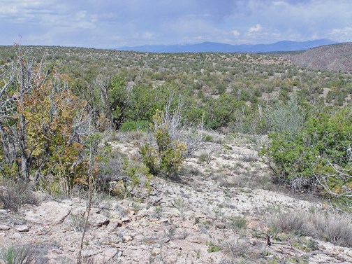
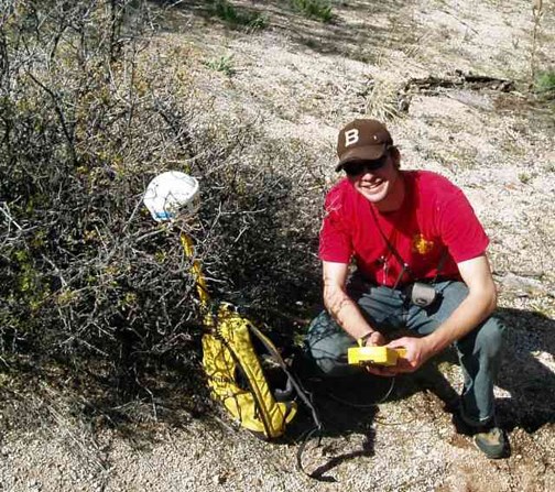
The ecology group has recently undertaken an effort to precisely map 1,000s of trees in the piñon-juniper woodlands of Bandelier. Using sophisticated GPS technology and a laser rangefinder we are able to map the trees with an accuracy of 15cm. This is 30x more accurate than a normal handheld GPS unit. The piñon-juniper woodland has seen significant changes in its species composition since the establishment of Bandelier National Monument. When the monument was first established ponderosa pine extended much further down the mesas than it does today. In the 1950s a mega-drought effected the southwest, during which much of the area experienced dry conditions not seen since the late 1500s. During the drought most of the lower elevation ponderosa on the mesas died. You can still see many of the dead pines as big old logs on the ground as you walk down the burro trail. Occasionally you will even see a tall standing ponderosa carcass. But for the most part ponderosas are now only able to survive in the wetter drainage bottoms, not on the drier lower mesas. Before management of the mesas of Bandelier was under the jurisdiction of the federal government the piñon-juniper woodlands were heavily grazed by sheep and cattle. This led to suppression of low-severity surface fire as the grazers removed much of the fine fuels that would normally carry the fire. This indirect fire suppression transitioned into direct fire suppression in the early years of the Park Service. Fire suppression combined with continued land degradation through top soil erosion and grazing by an exotic feral burro population led to a "woodification" of the low elevation mesas. Woodification means the major portions of the mesas were once a more savanna-type system with large patches of grass separating relatively few trees but then gradually became a dense woodland of piñon and juniper.Because of the continued woodification of Bandelier's mesas an ecological restoration (https://www.nps.gov/band/parkmgmt/restore.htm) project was undertaken. This project involved many partners, and years of research. The treatment method was fairly simple and basic; trees within a certain size class would be cut into many pieces and their limbs and branches scattered into the open bare areas. The result is an increase in herbaceous plants (grasses, perennial flowers) due to a decrease in erosion and an increase in cooler moist places for plants to establish.
During the experimental stages of the ecological restoration in the early 2000s another drought hit the JemezMountains. This drought devastated the mature piñon pine, killing over 95% of the mature trees. The restoration treatment eventually was fully implemented using live junipers and the standing dead piñon trees. The ecological restoration work now covers large portions of the low elevation mesas in Bandelier. In the ten years since the piñon trees died most of them have fallen over. The fallen trees have similar effects as the trees cut for the restoration treatment. It is common to see herbaceous plants and tree seedlings growing from under the branches of these fallen trees. As our mesas continue to change the ecology group will be able to locate the trees on their demography plots more easily, due to the precision of our mapping effort. We will be able to assess mortality and germination rates, as well as changes in size and age class distribution. We have partnered with researchers from LANL and the University of Idaho to attempt to use remote sensing imagery to create models that assess forest health and recognize early signs of forest stand mortality. Our collaborators are able to use the highly accurate location and demographic data to "teach" their models what to look for when trees start to die. The next step will be to scale these models up from relatively small pieces of landscape to entire mountain ranges or forested regions. Combining precise field data with the ability to monitor forests using remote sensing gives land managers current, accurate, and broad-scale data to use in decision making.
June 2012
Working with Onsite Science: A Place-Based Approach to Science for Land Management
Natural resource managers entrusted with the stewardship of our public lands have long known that decision-making related to restoring, managing, and protecting these ecosystems in a sustainable way is complex. They need relevant, up-to-date information to understand and manage specific landscapes. Much research on public wildlands, however, is conducted by scientists based out of university or urban research centers distant from the land and its local managers. Although these research efforts result in valuable findings, the information may not address site-specific management needs.
Adaptive, science-based land management-in which information on status and trends in an ecosystem is continually collected, analyzed, and communicated-is generally accepted as the desired approach for managing ecosystems on public lands (Johnson et al. 1998). Such ecological knowledge is often time and place specific. If there are substantial knowledge gaps in this realm, land managers struggle to make sound science-based decisions. On the other hand, when scientists can interact onsite with managers on a daily basis, effective communication, application, and follow-through of relevant science are greatly facilitated. This is where a place-based approach to science can help.
Bandelier has onsite scientists researching: cultural resources, ecology, wildlife, vegetation and fire effects. These scientists, act as a bridge between research and management, working to identify the information needs, secure external research funding, foster collaborations with outside institutions to conduct needed research, and communicate research findings quickly and effectively to local managers and the public. Place-based scientists develop substantial expertise in the natural dynamics of their particular landscape. Eventually this allows them to become information brokers of the deep-rooted institutional knowledge that comes from being in a place long enough to learn its lessons and grow familiar with its natural and cultural rhythms and history.
Good examples of on-site, place-focused research programs are found at a number of National Park Service units, where individual scientists have devoted major portions of their careers to working in particular landscapes. Such examples suggest that developing long-term, landscape-scale, on-site science programs could be a cost-effective way to meet critical information needs for many public land managers. Establishing additional place-based scientists could foster the development of land management organizations that institutionalize scientific approaches to learning, collaboration, open dialogue, and continual improvement-agencies that truly implement science-based adaptive management.
Resources and References
Adapted with permission from: Allen, CD. A Sense of Place: A Place-Based Approach to Science for Land Management. USGS https://www.fort.usgs.gov/resources/spotlight/place/Default.asp
Johnson, N.C., A.J. Malk, R.C. Szaro, and W.T. Sexton (eds.). 1998. Ecological stewardship: A common reference for ecosystem management. Vols. I-III. Elsevier Science Ltd., Oxford, UK.
Last updated: February 24, 2015
Park footer
Contact Info
Mailing Address:
Bandelier National Monument
15 Entrance Road
Los Alamos,
NM
87544