Last updated: March 12, 2024
Article
Thomas Cresap and Maryland’s Colonial Frontier
One of the most famous figures in the history of colonial Maryland is frontiersman Thomas Cresap. Cresap was a hired ruffian, an Indian trader, a land speculator, a farmer, and a soldier. During the French and Indian War his house was, for a time, the furthest westward point of British control in the Middle Atlantic region, which was discovered through archeology at the Chesapeake & Ohio Canal National Historical Park.
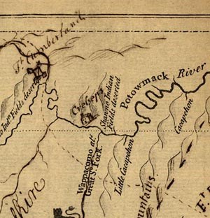
Thomas Cresap was far from the first person to live at this strategic spot on the upper Potomac River. The original grant or “patent” for this land, taken out in 1736, called the spot “Indian Seat.” The patent says that Indian Seat was located “at the Old Indian Town upon Potomack whereon a Certain Charles Anderson made some Cultivations.” More information on this “Old Indian Town” is provided by a map of the Potomac made by surveyor Benjamin Winslow in 1736. This map shows Charles Anderson’s house and, nearby “Shawno Old Fields Deserted.” The Old Indian Town was a residence of the Shawano Indians or, as we call them, the Shawnee. In fact, this town was the one called by the British authorities King Opessa’s Town, a Shawnee settlement occupied from about 1715 to 1732.

Charles Anderson was an Indian trader and one of the first white settlers along the upper Potomac. Like many Potomac frontiersmen, he was not British. He was a Finn, whose ancestors had immigrated to New Sweden, the Swedish colony along the Delaware River. That colony had been conquered by the Dutch, then the English, and absorbed into Pennsylvania, but the Swedes and Finns still retained their identity and their close alliance with the Susquehannocks and other Indian tribes. Thanks to their Indian connections and their in-between status, neither Indian nor British, the Finns for a time dominated the Indian trade along the upper Potomac.
By 1746, Charles Anderson had moved on farther west, and the Indian Seat patent had been taken over by Thomas Cresap. On this spot Cresap established a cabin, fort, and trading post. Cresap was born in Yorkshire, England, in 1694 and came to America at the age of 15. In the 1730s he had been a land agent for the Calvert family of Maryland in their border dispute with the Penns of Pennsylvania. This conflict is sometimes known as Cresap’s War, making Cresap part of that select band of men, like Napoleon and Red Cloud, who have their own wars. This dispute was about unsettled lands west of the Susquehanna River, in present-day Lancaster and York counties, Pennsylvania. Cresap had a house near Wrightsville. The Pennsylvania authorities accused Cresap of murder, and in 1736 his house was surrounded by an armed company of 24 Pennsylvanians, led by the Sheriff of Lancaster County. Cresap was captured only after the sheriff’s men set his house on fire. He was taken to Philadelphia and imprisoned for two years, earning his release as part of an overall truce between the Calverts and the Penns.
After leaving Philadelphia, Cresap moved his family west, settling for a time on Antietam Creek and then moving farther west to Oldtown. Cresap bought the land in 1746, but he may have been residing there for some time, since the 1744 Treaty of Lancaster mentions his residence. In this treaty the Six Nations of the Iroquois Confederation relinquished their rights to land west of the Alleghany Mountains and south of the Ohio River and also agreed to relinquish all their rights to western Maryland to Lord Baltimore:
as far as two miles above the uppermost Fork of the Potomac or Cohongoronto river near which Thomas Cresap has a Hunting or Trading Cabin, in consideration of £300 payable in goods.
Cresap’s strongly stockaded house and trading post was located near a well-known crossing along the Warrior’s Path from the Iroquois homeland to the south, an ideal place for a trader to settle. Over the years that followed he claimed several more parcels of land, eventually owning thousands of acres.
Cresap’s cabin at Oldtown became a landmark and waypoint for Europeans traveling in western Maryland, Virginia, and Pennsylvania. In 1747, a 15-year-old George Washington visited Cresap’s cabin while working on the survey of Lord Fairfax’s western lands, and he was stranded there for five days by heavy rains. From his journal it is possible to get a glimpse at what life was like for Thomas Cresap in Oldtown. On his third day Washington wrote:
Wednesday 23d. Rain’d till about two oClock & Clear’d when we were agreeably surpris’d at the sight of thirty odd Indians coming from War with only one Scalp. We had some Liquor with us of which we gave them Part it elevating there Spirits put them in the Humour of Dauncing of whom we had a War Daunce. There Manner of Dauncing is as follows Viz. They clear a Large Circle & make a great Fire in the Middle then seats themselves around it the Speaker makes a grand Speech telling them in what Manner they are to Daunce after he has finish’d the best Dauncer Jumps up as one awaked out of a Sleep & Runs & Jumps about the Ring in a most comicle Manner he is followd by the Rest then begins there Musicians to Play the Musick is a Pot half of Water with a Deerskin Streched over it as tight as it can & a goard with some Shott in it to Rattle & a Piece of an horses Tail tied to it to make it look fine the one keeps Rattling and the other Drumming all the While the others is Dauncing.
By 1749, Cresap was a member and agent of the Ohio Company of Virginia, serving as trader and speculator in their newly acquired lands in the Ohio Valley. He helped the Delaware chief Nemacolin lay out a rugged 60-mile trail from the Potomac River to the Monongahela, opening the road to the west. Over the years the trail would come to be known by several names, including Nemacolin’s Trail and Braddock’s Road.
When war broke out between France and England in 1754, Cresap found himself on the front line. His sons organized a ranger company, and his blockhouse provided shelter for many neighbors during the conflict. In May 1755, half of General Braddock’s army stopped at Cresap’s cabin on their way to disaster in western Pennsylvania. One of Braddock’s officers kept a journal of the campaign and he described his short stay:
May 8th. Ferried over the River into Maryland; and March’d to Mr. Jackson’s, 8 Miles from Mr. Coxs’s where we found a Maryland Company encamped in a fine Situation on the Banks of the Potomack; with clear’d ground about it; there lives Colonel Cressop, a Rattle Snake, Colonel and a D — d Rascal; calls himself a Frontiersman, being nearest the Ohio; he had a summons sometimes since from the French to retire from his Settlement, which they claim as their property, but he refused it like a man of Spirit; This place is the Track of Indian Warriours, when going to War, either to the No’ward, or So’ward. He hath built a little Fort round his House, and is resolved to keep his Ground. We got plenty of Provisions. &ca. General arrived with Captains Orme and Morris, with Secretary Shirley and a Company of light Horse for his Guard, under the Command of Capt. Stewart, the General lay at the Colonels.
After General Braddock’s army was defeated by the French and their Indian allies, on July 9, 1755, the whole frontier was thrown open to attack. Cresap’s stockade at Oldtown served as a haven for the refugees fleeing the Ohio Valley and western Maryland. At first, Cresap’s was one of several stockades or blockhouses located up and down the Potomac River in western Maryland. As the war continued, settlement after settlement along the upper Potomac was raided and burned by Indian parties aligned with the French. Those that were not yet destroyed were often abandoned. By the winter of 1755, only Cresap’s fort at Oldtown remained. Aware that he was alone and vulnerable, Cresap removed his family to his son Michael’s plantation on Conococheague Creek. Cresap’s eldest son, Thomas, was one of the many killed in the fighting.
The British conquest of Fort Duquesne in 1758 ended the fighting on the upper Potomac. Based on Maryland Land Records, Thomas Cresap picked up where he left off, selling and trading tracts of land along the upper Potomac River. By 1765, his son, Michael, had joined his father as a land speculator and broker. In October 1765, Michael had surveyed 1,706 acres north of Oldtown. A few months later, in March 1766, he patented the land, calling it “Seven Springs.” The Cresaps founded a town, the future Oldtown, on this land, and began selling lots. Oldtown never prospered, though, and Cresap settled down as a gentleman farmer. In 1765, he was active in the agitation against the Stamp Act, and he was a proponent of Revolution from Britain. He lent his support to various schemes for canals or roads to the west, but never moved farther west himself. He died at Oldtown in 1790, at the age of 96.

NPS.
Cresap’s Fort
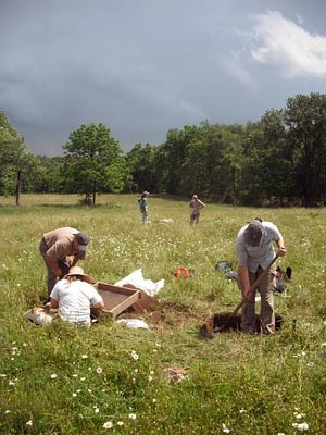
From 2008 to 2010, an archeological survey of the upper third of the Chesapeake & Ohio Canal National Historical Park from mile marker 123 to 184 was completed. Along this 61 miles of the Potomac, from Hancock to Cumberland, 52 new archeological sites were found and more was learned about 6 already known sites. The sites in this part of the park include at least three Late Woodland Indian villages, dating to 1000 to 1550 CE, and dozens of small prehistoric camp sites. Intact, buried deposits were found at some sites dating back 3,000 years, to the Early Woodland period. Brick kilns and the foundations of a warehouse were found that were used during the construction of the C&O Canal, in the 1840s.
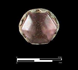
Because Cresap’s Fort was such an important historical site, many people have tried to find it, and over the years there have been several theories as to where it might have been. One contribution of the recent archeological study was to confirm that one of those theories was right. The fort was in a hayfield south of Oldtown, on a high terrace about a thousand feet from the river. The excavation of seven 3 by 3 foot test units here produced more than 200 artifacts dating to 1740 to 1770. The artifacts include oriental porcelain, Delftware, white salt-glazed stoneware, brown stoneware, Rhenish blue and gray stoneware, coarse red earthenware, olive wine bottle glass, case bottle glass, white clay pipe stems and bowl fragments, a gunflint of English flint, two lead shot of about .30 caliber, a small lead shot, hand-wrought nails, and a substantial amount of window glass. Especially intriguing is a single paste gemstone, probably once part of a button, cufflink, or shoe buckle. As one of the largest collections of colonial artifacts found in western Maryland, this site represents a major colonial settlement, and provides evidence for the location of Cresap’s Fort.

NPS.
The artifacts found on the site include a great many nails and a few bricks. The brick is probably from the hearth of the chimney; since there was not enough brick for a complete chimney, the rest of it was presumably built of logs, lined with mud. Log houses could be built with very few nails, so the nails from this site suggest that the original log house was added to or modified over the years. Many pieces of broken bedrock were also found across the site. Bedrock is buried deeply enough beneath this part of the terrace that these rocks were probably not turned up by the plow. The rock is mostly in pieces fist-sized or smaller, but the rock is soft and was easily broken with a shovel. Most likely this stone is the remains of the foundations of log structures, including Cresap’s house.
Not only is Cresap’s Fort an important historical site, it is a rare representative of colonial settlement along the Potomac frontier. Eighteenth-century frontiersmen were highly mobile and traveled light, and their log cabins could be built without nails or substantial foundations. They left so little behind them that it has proved very difficult to find archeological evidence of their homes. Cresap’s Fort is one of the most significant colonial archeological sites found in western Maryland, yielding a collection of artifacts that can be used to study life on the frontier. The site was an important discovery, and has continued to inform the history of the colonial period in western Maryland.
By John Bedell, Ph.D. The Louis Berger Group, Inc.
