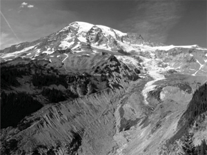
During a storm in 2010, the Nisqually River swept away the embankment of Nisqually Road at mile point 6.0. The root of the damage? Glacial retreat due to climate change.
Aggradation and Avulsion

NPS photo
Since 1913, glacial retreat has exposed an area of 37.5 km2 (14.5 mi2) of Mount Rainier National Park lands. As a result, when a storm crosses the park, it washes the boulders, rocks and soils previously capped by the glaciers into the rivers and creek beds, filling them up. This process, called "aggradation," results in more frequent "avulsions," or overtopping, from rivers and creeks. Avulsions can also act like a fire hose targeted on one area of the river bank, causing erosion.
Problem is, the river banks at Mount Rainier hold up historic roads, including major passages for park visitors. The Nisqually Road, for example, is part of the Mount Rainier National Historic Landmark District, which includes the park's historic roads and infrastructure. Most of the park's 2 million visitors per year travel along the Nisqually Road to Paradise.
Because the historic roads are being increasingly damaged by flooding during storm events, the NPS is evaluating methods to repair the riverbanks supporting them. They aim to balance the look and feel of the historic landscape with engineering to keep the roads—and the people who drive on them—safe.
Riprap

NPS photo
Between 1906–1957, park roads were built with naturalistic embankments. Planted and built up with native vegetation and wood, the steep road embankments were often stabilized with stacked and spiked logs, or log lattices that would be backfilled with soil and planted.
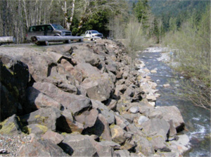
More recently, the park has used riprap to construct road embankments. Riprap consists of large angular rock that is imported into the park and poured and placed on an angle of repose.
Riprap is structurally stable in typical circumstances, and is a relatively cheap embankment material. But riprap doesn't hold up during avulsions; instead, it can easily be swept away by rapid water. It doesn't offer good habitat for fish or other aquatic species. And riprap isn't naturalistic, meaning it isn't compatible with the historic character of the road or the national historic landscape district.
Engineered Log Jams (ELJs)

NPS photo
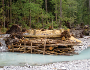
An alternative treatment is engineered log structures, including Engineered Log Jams (ELJs), some of which are similar in design to historic log cribbing. Along Nisqually Road, an engineered log structure was used to repair the road embankment. ELJs are a 3D matrix of logs with root wads and other logs, anchored into the river or creek bed, and backfilled with rock and sediment. The ELJ diverts current away from the embankment back to the center of the river or creek. It also acts like a trash rack, catching woody debris and allowing for the deposition of sediment. Over time, the ELJ grows riparian "real estate" around itself.
The ELJ is more durable than riprap. Its larger mass is more difficult to raft downstream than single rocks. It offers a rough surface akin to a debris-laden riverbank, which has more resistance than than relatively smooth riprap. Overtime, they enlarge themselves with debris and sediment, and allow for the establishment of riparian vegetation. They are also better than riprap at supporting aquatic habitats for fish.
Glacial retreat is having an ongoing impact on the Nisqually Road. But with new treatment techniques, the National Park Service can adapt to climate change effects and preserve historic roads for safe driving.
Learn more
Find out the Road Status of Nisqually and other roads at Mount Rainier.
Read about the historic roads of Mount Rainier in "Highways In Harmony": a history of Mount Rainier's roads, bridges, and transportation system.
Last updated: November 4, 2019
