Part of a series of articles titled Coastal Geomorphology—Storms of Record.
Previous: Storms in the Geologic Record
Article

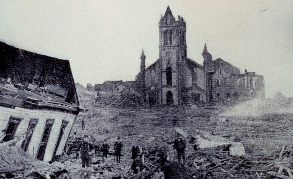
Library of Congress image.
Established in the 1960s and 1970s, all of the National Park System units on the coast of Texas are young. Indeed the seascapes themselves are geologically youthful (i.e., covered by Pleistocene and Holocene landforms). Although predating the establishment of national parks in Texas, the hurricane that made landfall at Galveston, Texas, in 1900, was in the vicinity of what is now Padre Island National Seashore (authorized in 1962). Although the “Great Galveston Hurricane” also occurred before the establishment of the Saffir-Simpson hurricane scale, this estimated category 4 storm is still considered the United States’ deadliest natural disaster. The storm’s sustained wind velocity, which was registered before the anemometer blew away, was 84 miles per hour (135 kph), but gusts of 100 miles per hour (161 kph) had been recorded. Later, meteorologists estimated that wind speeds probably reached 140 miles per hour (225 kph) (City of Galveston 1900 Storm Committee 2010). The storm surge, estimated at 15.7 feet (4.8 m), swept ashore in advance of the hurricane’s vortex and caused a sudden rise in water depth, inundating most of Galveston Island and the City of Galveston. At the time, the highest elevation on Galveston Island was 8.7 feet (2.7 m) (City of Galveston 1900 Storm Committee 2010).
The hurricane occurred before the implementation of assigning official names to tropical storms, and thus it is commonly referred to by a variety of descriptive names: “Galveston Hurricane of 1900,” the “Great Galveston Hurricane,” and, especially in older documents, the “Galveston Flood.” However, for Galveston locals, even today, reference to “the storm” always means the hurricane that tore across Galveston on 8 September 1900 and left the city in ruins (Lutz 2010).
Between 6,000 and 8,000 people in the city died as a result of the storm. Estimated casualties for the entire island range from 10,000 to 12,000. For comparison, Hurricane Katrina (2005), the deadliest storm of recent times, claimed the lives of approximately 1,500 people (Blake et al. 2007). Property damage caused by the 1900 hurricane is difficult to estimate by current standards, but contemporary figures range from $20 million to $30 million; 2,636 houses were destroyed, and 300 feet (91 m) of shoreline eroded. The 16 ships anchored in the harbor at the time of the storm also suffered extensive damage (Weems 2009).
This hurricane had been first observed on 30 August in the vicinity of 15°N latitude and 63°W longitude, about 125 miles (201 km) northwest of Martinique, proceeding westward. Galvestonians had been aware of the storm since 4 September when it was reported moving northward over Cuba. From the first, however, details had been sketchy because of poor communications. In 1900, ships at sea had no way of telegraphing weather observations ashore. Furthermore, Galvestonians had become used to occasional “overflows” when high water swept beachfronts. Therefore, comparatively few people had evacuated the city before bridges from Galveston Island to the mainland collapsed (Weems 2009). Many people along the beach waited until too late to seek shelter in large buildings downtown, away from the Gulf of Mexico. Houses near the beach began falling first. The storm lifted debris from one row of buildings and hurled it against the next row until eventually two-thirds of the city, then the fourth largest in Texas, had been destroyed. People trying to make their way through wind and water to refuge were struck by hurtling bricks and lumber and sometimes decapitated by flying slate from roofs (Weems 2009). The great storm that wrought so much destruction on Galveston Island also left a long track: from Texas it traveled into Oklahoma and Kansas, turned northeastward and crossed over the Great Lakes and into Canada, and on 12 September passed north of Halifax and disappeared into the North Atlantic (Weems 2009).
Many observers predicted that Galveston would never recover and urged that the island be abandoned. However, out of the chaos, the citizens of Galveston rebuild the city, making it less vulnerable to future storms and flooding; they also reformed the city in a thoughtful, intentional way (Bixel and Turner 2000). In addition, the citizens reinvented city government, developing the commission style of government now used by many municipalities, and gave women a larger role in public life (Bixel and Turner 2000). Furthermore, the storm prompted the construction of a 6-mile- (10-km-) long seawall, which has since been extended. Inside the city, sand pumped from the Gulf of Mexico elevated the grade as much as 17 feet (5.2 m). This work required the advanced raising of 2,146 buildings and many streetcar tracks, fireplugs, and water pipes, as well as the salvage of trees, shrubs, and flowers (Weems 2009).
Part of a series of articles titled Coastal Geomorphology—Storms of Record.
Previous: Storms in the Geologic Record
Last updated: May 30, 2019