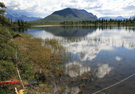
In the Central Alaska Network (CAKN), over 25,000 shallow lakes and ponds (lakes <16ft/5m deep) are distributed across the landscape, and these systems are an ideal context to monitor environmental change.

NPS Photo / Heidi Kristenson
When people think of Alaska parks they rarely think of the large flat expanses of land that predominate in much of the state. Wetlands occupy almost half of Alaska, including much of the state’s public lands. These large expanses of wetlands provide habitat for moose to feed on new willow growth, for birds to nest and for beaver and muskrat to build lodges. Yet, it is in these largely pris-tine systems where scientists are seeing the first signs of climate change. These changes appear to be related to global warming, and scientists predict that these systems will show some of the greatest impacts of climate change. In the Central Alaska Network (CAKN), over 25,000 shallow lakes and ponds (lakes <16ft/5m deep) are distributed across the landscape, so these systems are an ideal context to monitor environmental change.
Because the wetlands in CAKN are relatively free of direct human modification like human sewage or industrial effluent, we have designed a unique monitoring program that has four basic elements:
- traditional measures of the physical and chemical properties of water
- water quantity
- physical structure of shallow lakes, and
- internal biological assessments including vegetation and macroinvertebrates.
Data from our monitoring in Denali National Park and Preserve (DENA) has already yielded interesting results. Water level in lakes in DENA declined 6 inches (16 cm) on average between 2006 and 2007, however some lakes dropped as much as 42 inches (107 cm). When we compared aerial photographs taken in 1980 with satellite images from 2007, we detected large differences large differences in lake surface area. In the first area (Minchumina basin), lakes did not change from 1980 to 2007.
However in the other area (Eolian lowlands) a dramatic 26% of the lakes had shrunk in 27 years. Another 19% had dried from lakes to become wet meadows. We believe the explanation for this is the soil surrounding the lakes. In the Minchumina basin, lakes are enveloped by frozen ground that stops water from draining out of the lake, and the ground is insulated by a thick organic layer that protects the permafrost from melting. Lakes in the Eolian lowlands are surrounded by sandy soils that water percolates through. If a warming climate causes frozen soils to melt, we expect to see lake level changes in the Minchumina basin in the future.
One of the next steps we are undertaking is to take sediment cores from lakes to see how lake levels have fluctuated over the past 8,000 years. At present it is not known if lakes have dried and recovered in shorter time periods (e.g. 50 years). When we compared aerial photo-graphs taken in 1980 with satellite images from 2007, we detected large differences in lake surface area. This, in turn, will help park managers determine what manage-ment actions are most appropriate for parks.
Part of a series of articles titled Alaska Park Science - Volume 9 Issue 1: Monitoring the "Vital Signs" of Healthy Park Ecosystems .
Last updated: December 31, 2014
