NPS photograph
Introduction
Katmai National Park and Preserve (Katmai), located on the Alaska Peninsula, is home to one of the largest protected populations of brown bears (Ursus arctos) in the world (Sellers et al. 1999). A recent population survey in 2004 and 2005 estimated 2,183 ± 379 brown bears within the park boundary (Olson and Putera 2007). Concentrated food resources along salmon streams and coastal foraging sites result in seasonal aggregations of bears. The spatial and temporal activity of these animals in relation to their habitat has not been well studied, despite extensive general knowledge of these activity patterns in many locations. Documentation of activity patterns is important to park managers: changes to these patterns may reflect changes in food availability or habitat over time, or behavioral responses to development or human activity.
NPS photograph by Carissa Turner
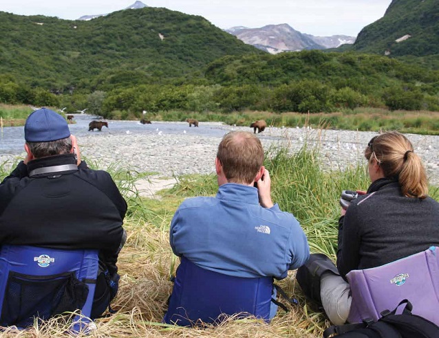
There are several remote backcountry areas in the park that have seasonal aggregations of brown bears. Many of these areas also attract bear viewers and wildlife photographers. Visitation to backcountry bear viewing locations has increased in recent years (Kim 2008). Human presence at brown bear foraging areas has the potential to alter bear use (Olson and Gilbert 1994, Olson et al. 1997, Smith 2002, Smith and Johnson 2004, Nevin and Gilbert 2005).
In 2004, Katmai initiated a study using time-lapse photography at the lower Brooks River. The purpose of the study was to analyze bear use in and around the river crossing (a floating boardwalk) and evaluate whether or not repositioning the boardwalk may reduce human-bear interactions (Hamon et al. 2007). In 2007, the time-lapse study was expanded to the backcountry as a tool to monitor bear use of remote foraging sites.
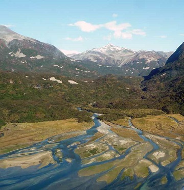
Geographic Harbor was the first backcountry site where bear use was monitored using time-lapse photography (Figure 2). Bears make use of several foraging resources in the narrow bay: clam beds exposed on the intertidal flats at low tide, high protein sedge meadows, and seasonal salmon runs. Visitors are attracted to Geographic Harbor for bear viewing and photography. The combination of bear and human use at this site provides park researchers with an opportunity to document bear and human activity patterns and changes in bear activity in the presence and absence of people.
NPS photograph by Carissa Turner
Methods
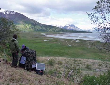
In 2007, 2008 and 2009, cameras with time-lapse con-trollers were set up on a hillside overlooking Geographic Harbor. The cameras were set to take photos at regular intervals to capture bear activity from June to September. The camera (Figure 3) was visited regularly to change memory cards and conduct maintenance as needed.
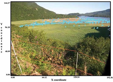
Data was later collected from each usable photo. Photos were imported into ArcMap® with a standard x/y coordinate reference system. Each bear, person, boat and plane were identified and marked as a point feature (Figure 4). A relative tide stage point was also marked. Geodatabases were used to store object identification, spatial (x/y coordinate), and time and date information for each photograph.
Photo object data was analyzed to compare bear numbers in relation to day of year, time of day and tide stage. The number of people in photographs was also compared by day of year and time of day. Primary bear activity and bear viewing time periods were determined through these analyses. In addition, the data was used to compare bear numbers and bear spatial distributions in the presence and absence of people.
Results and Discussion
During the three years of the study, bears were observed in 61% of usable photos and people were observed in 18% of usable photos. Not all photos could be scored due to weather and low light conditions. In some cases, objects in groups (such as close knit visitor groups) were hard to distinguish from each other, so scored data represent minimum estimates when people or bears are clumped.
Bear and Human Activity and Day of year
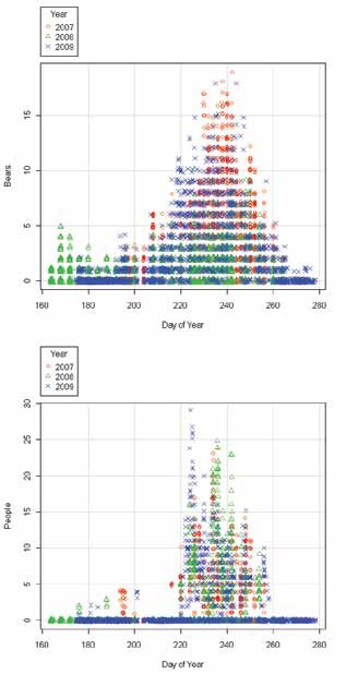
Bears were observed as early as June 12 (2008) and as late as October 3 (2009). Over 90% of bear activity occurred between July 23 and September 17, with the peak observed in late August (Figure 5). This activity corresponds with Geographic Creek’s seasonal salmon runs.
Visitors were observed as early as June 24 (2008) and as late as September 15 (2009) in Geographic Harbor. During the three year study, human activity peaked between August 18 and August 25 (Figure 6). Approximately 95% of human activity occurred between August 4 and September 12. Bear viewing accounts for 93% of visitor activity at Geographic Harbor and the Amalik Bay area, according to Katmai’s commercial use data. This explains the observed concentrated visitor use during peak bear activity.
Bear and Human Activity and Time of Day
Bears were observed at all times of the day; however, two prominent peaks in bear activity were observed during daylight hours (Figure 7). The first peak occurred in the morning (approximately 6:00am to 12:00pm) and the second occurred in the evening (approximately 6:00pm to 10:00pm). In all three years, a decrease in bear activity was observed between these two peak periods.
Visitors were observed as early as 8:50am (August 13, 2009) and as late as 9:51pm (August 22, 2009). There was one peak in visitation during the day, which occurred from 10:00am to 4:00pm (Figure 8). Almost 80% of visitation occurred during this timeframe.
Bear use in the presence and absence of visitors
The highest number of bears counted in a photograph was 19, recorded on August 30, 2007 at 7:11am. Simi-larly high numbers of bears were recorded in 2007 (18), however significantly fewer bears were recorded in 2008. The maximum number of bears in the 2008 photographs was 10 (August 13). Overall, the average number of bears recorded was four in both 2007 and 2009, and two in 2008. The cause for lower bear numbers in 2008 is unknown, but may indicate lower food availability at the site.
Visitor numbers ranged from one to 29, with the highest count occurring on August 12, 2009, at 3:50 pm. The number of people in the photographs was similar in all three years. During times of visitation, the average number of people was seven, and the most common number of people counted was six. Average numbers of visitors did not change significantly over the three years, even though bear activity was lower in 2008.
To determine whether or not bear activity changes with human presence, the number of bears can be compared to the number of people in photographs. Figure 9 illustrates this comparison; a general decrease in maximum bear numbers is observed as human numbers increase. Bears are not seen in numbers greater than 8 when there are more than 16 visitors present.
Spatial data was also used to evaluate bear use. X/Y coordinates collected from photographs allow for comparison of bear distribution during time of visitation and times without visitors present. During primary bear use (late July through mid-September), bear activity is focused in Geographic Creek and the river corridor.
For ideal bear viewing, visitor groups distribute themselves along the banks of Geographic Creek. This has the potential to displace foraging bears, or alter their feeding patterns and locations (Olson and Gilbert 1994, Olson et al. 1997, Smith 2002, Smith and Johnson 2004, Nevin and Gilbert 2005).

Management Implications
Time-lapse photography is a relatively cost-effective method for monitoring bear activity at remote foraging sites, and allows for data collection in the absence of people. Katmai is expanding this project to other areas within the park and is currently setting up seasonal cameras at another foraging site that does not attract visitors. This research control site will provide baseline bear activity data for comparison with Geographic Harbor and other sites where visitation is common.
Evidence of changing bear presence and habitat use with changing visitor use levels warrants additional monitoring and research. Long-term data collection and analysis of bear use at remote foraging sites will help Katmai staff to identify natural and human-caused changes in bear activity, and resource management options for mitigating negative impacts to brown bears. By understanding bear use activity patterns at foraging sites and changes in bear numbers and spatial distributions with visitation, park managers and guides will be better able to adapt tourism and management activities to protect natural bear population dynamics and maintain high quality wildlife viewing experiences for the public.
References
Hamon, T.R., H.S. Kim, T.L. Olson, and T. Harrington. 2007. Determining bear activity levels in the lower Brooks River, an area of high visitor use in Katmai National Park, Alaska. Katmai National Park and Preserve. King Salmon, AK.
Kim, H.S. 2008. Backcountry visitor impact assessment in Katmai National Park and Preserve and the Alagnak Wild River, 2007. Katmai National Park and Preserve. King Salmon, AK.
Nevin, O.T., and B.K. Gilbert. 2005. Perceived risk, displacement and refuging in brown bears: Positive impacts of ecotourism? Biological Conservation 121: 611-622.
Olson, T.L., and B.K. Gilbert. 1994. Variable impacts of people on brown bear use of an Alaskan river. International Conference on Bear Research and Management 9 (1): 97-106.
Olson, T.L., B.K. Gilbert, and R.C. Squibb. 1997. The effects of increasing human activity on brown bear use of an Alaskan river. Biological Conservation 82: 95-99.
Olson, T., and J. Putera. 2007. Refining techniques to survey harvested brown bear populations in Katmai National Park and Preserve and Lake Clark National Park and Preserve. Katmai National Park and Preserve, Lake Clark National Park and Preserve. King Salmon, AK and Port Alsworth, AK.
Sellers, R.A., S. Miller, T. Smith, and R. Potts. 1999. Population dynamics of a naturally regulated brown bear population on the coast of Katmai National Park and Preserve. National Park Service and Alaska Department of Fish and Game. Anchorage, AK.
Smith, T.S. 2002. Effects of human activity on brown bear use of the Kulik River, Alaska. Ursus 13: 257-267.
Smith, T.S., and B.A. Johnson. 2004. Modeling the effects of human activity on Katmai brown bears (Ursus arctos) through the use of survival analysis. Arctic 57 (2): 160-165.
Part of a series of articles titled Alaska Park Science - Volume 10 Issue 2: Connections to Natural and Cultural Resource Studies in Alaska’s National Parks.
Last updated: August 9, 2016
