Last updated: September 3, 2023
Article
Secrets of the Summit
NPS Photo
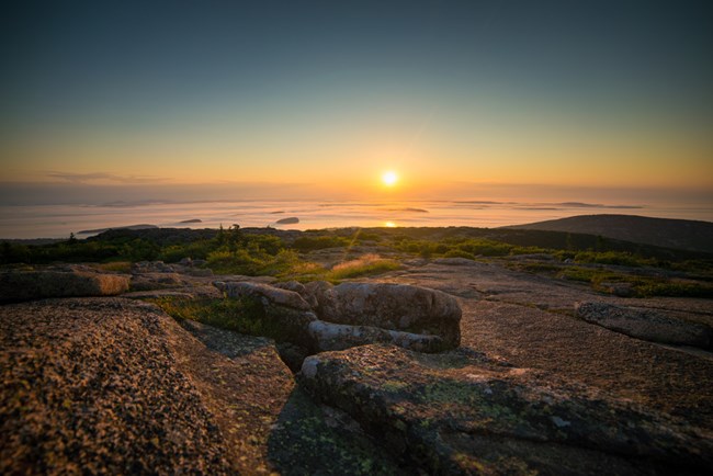
Wabanaki communities, who were this island's first inhabitants and continue to call this place home, the early tourists and Rusticators, and modern visitors have all experienced the beauty of its trails, the awe of its views, and the power of its landscape.
Why does Cadillac's Summit Look Like it Does?
NPS Photo
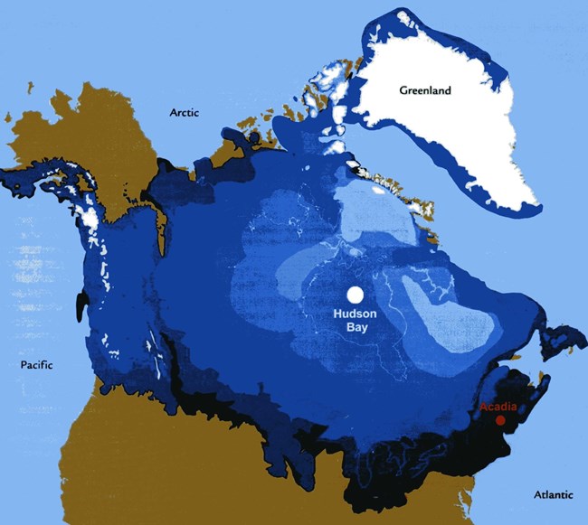
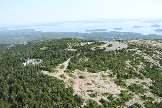
During the last ice age, a glacier covered most of what is no Canada and Northern U.S, including Acadia. Known as the Laurentide Ice Shet, it towered about a mile high. It's movement, from north to south, carved the landscape to the shape we see today. When the Laurentide Ice Sheet melted away, it exposed the dramatic landscape of what is now Acadia National Park. You can see its effects throughout Acadia, including the bald peaks of the mountains and the large rocks that seem to be in peculiar places. The little soil that was left behind helped pave the way for the subalpine vegetation found on the summits today.
Because there isn’t much soil at the top, plants have to be very specialized to live there. These specialized plants can use this rocky habitat because they have adapted to little or no soil, harsh winter conditions, and low water supply. The harsh winds can even dry out their needles! Although all these forces make the summit habitat seem too difficult to survive, a select few plants persevere. Species like the pitch pine have adapted to these conditions and have waxy needles to help prevent desiccation and freezing, and their dark green color helps absorb sunlight in the early spring.
But Why the Name "Cadillac?"
Now that we are familiar with the habitat atop Cadillac Mountain, let's talk about who used this land historically, and why. Long before cartographer Samuel de Champlain named this place Isle des Monts Deserts (Island of Barren Mountains) in the early 1600s, Wabanaki peoples used the island as a central meeting place to gather, trade, hunt, and fish with one another. Collectively, four tribes are known as Wabanaki: the Maliseet, Micmac, Passamaquoddy and Penobscot. Many knew this island as “Pemetic” meaning “range of mountains.” The name Wabanaki also reflects the magnificent landscape; it translates to “People of the Dawn Land.”
The island's tallest mountain has had many names. One Wabanaki name for it was Pesamkuk. Euro-American settlers called it Green Mountain, until 1918 when the mountain was named Cadillac Mountain, to honor the French nobleman, Antoine de la Mothe, who was gifted this land by the governor of New France in 1688. Cadillac’s name lives on both here, and in the city of Detroit, where he established a fort, and parish in the early 1700s. You can find Cadillac’s family seal at the top of Cadillac Mountain, but only the car; the company, founded in Detroit, adapted the seal for their emblem.
Did you know that most of Cadillac Mountain’s visitors have never been to the true summit? If you are familiar with the summit of Cadillac, you have probably visited the Summit Loop, a half mile trail around the eastern summit, but that is not actually the tallest part of the mountain! There are 3 summits, and the tallest one is about a 5-minute walk down the South Ridge Trail. As you find your way to the South ridge trail from the parking area, and begin walking, you may notice the trail is very wide, even big enough for a car to drive.
Historic Land Use
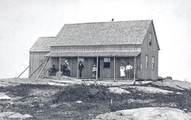
Photo courtesy of the National Park Service, Acadia National Park
The U.S. Coast and Geodetic Survey was installed in 1858, while the summit marker was installed in 1954. The Coast Survey was established in the early 1800s by President Thomas Jefferson and its goal was to survey & map the coast. The benchmark helped with mapping by being a point that surveyors knew the exact location of, helping to scale and orient the maps. The coast survey is now part of the National Oceanic and Atmospheric Administration, also known as NOAA.
Not only did the old roadbed led to the true summit of, but it was also built to take visitors up to Cadillac Mountains first hotel. To capitalize on the visitors coming to the top of Cadillac Mountain, the Brewer family, who previously owned what was then called “Green Mountain”, built The Mountain House in the early-1860s. It was located about 10 yards north of the summit. Before becoming a hotel, this structure was used to house the U.S Coast Survey workers. Early tourism was booming on Mount Desert Island and there was a demand for another hotel on top of Green Mountain.
A New Way to Traverse the Mountain
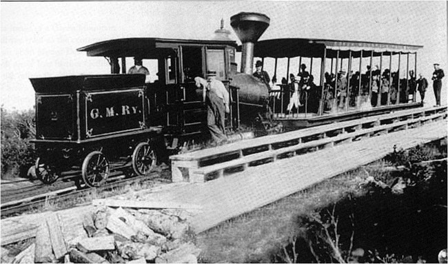
Photo courtesy of the National Park Service, Acadia National Park
Although you may think getting on the train is an easy solution to summiting the mountain, it is a bit of a crazy journey to get to get to the top via the cog railroad. After parking their horse drawn carriages at the North end of Eagle Lake, visitors would board the Wauwinet. The steamboat took them to the southeast end of the lake where passengers could board the Green Mountain Cog Railway. At just $2.50 round-trip, the train traveled at the lightning speed of 2 mph. Passengers would often get off and walk along the train to pick blueberries and jump back on. After arriving at the summit, passengers could enjoy the Mountain’s accommodations and stunning view.
One dreadful night in 1884, a small spark set ablaze the roof of one of the hotels: The Green Mountain House. As the whole building became engulfed in flames, the fire grew to the old mountain house, about 50 yards away. Residents of Otter Creek thought that visitors were having a large bon fire at the summit but soon realized it was much worse. Luckily, everyone escaped the blaze unharmed.Within 48 hours of the fire, Bar Harbor builder, John Clark, already had a new hotel drawn up on paper. Ground broke on a temporary structure not long after. Within a year of building the temporary right side of the hotel, the Summit house was completed and ready for guests. In 1889, the Hotel accommodated the US Signal Service, in which a weather station was located on the third floor.
In the 1890s, the visitation to Cadillac Mountain had slowed so much, that the Cog railroad was falling into extreme debt, the railroad was closed, and Frank Clergue and the Green Mountain Railway were in $14,000 of debt. The hotel was also short lived, little over 10 year after its completion, the structure had already fallen into disrepair due to the decreased visitation. Residents decided that the mountain would be more enjoyable with an expansive view of Mount Desert Island, the Summit House was torn down and burned. The cog railroad still lives on to this day, as you can find the original locomotive on display at the White Mountains National Forest.
A History of War
NPS Photo
Even lesser known, is that the summit of Cadillac Mountain played a key role in World War II. Although Cadillac Mountain was closed to visitors during this time, it was still in use. Due to its ideal location, the mountain was home to a World War II radar facility for early-warning aircraft detection. The mountains height and location gave strong radar signals and is the reason Acadia National Park still uses it for communications. The radio antenna on Cadillac Mountains is now used by the National Park Service, local police and fire departments, and the U.S. Coast Guard.
Physical change, a harsh environment, and historic human development may not be noticeable at a quick glance atop Cadillac Mountain, but the rich history of Acadia's tallest peak goes back thousands of years. Cadillac Mountain has not only changed names, but it has also showed a unique attempt to capitalize on tourism in the late 19th century. From the early visitors, to the massive railway operations, Cadillac Mountain has withheld the test of time. The harsh environment, however, has remained relatively unaltered. Nonetheless, the impressive vistas Cadillac Mountain has to offer have been enjoyed by millions.
